Jet Propulsion Laboratory California Institute of Technology Follow this link to skip to the main content
Images
Press Release Images
Spirit
Opportunity
All Raw Images
Spirit
Opportunity
Panoramas
Spirit
Opportunity
3-D Images
Spirit
Opportunity
Spacecraft
Mars Artwork
Landing Sites
Press Release Images: Opportunity
23-Jan-2014
NASA's Opportunity at 10: New Findings from Old Rover
Press Release
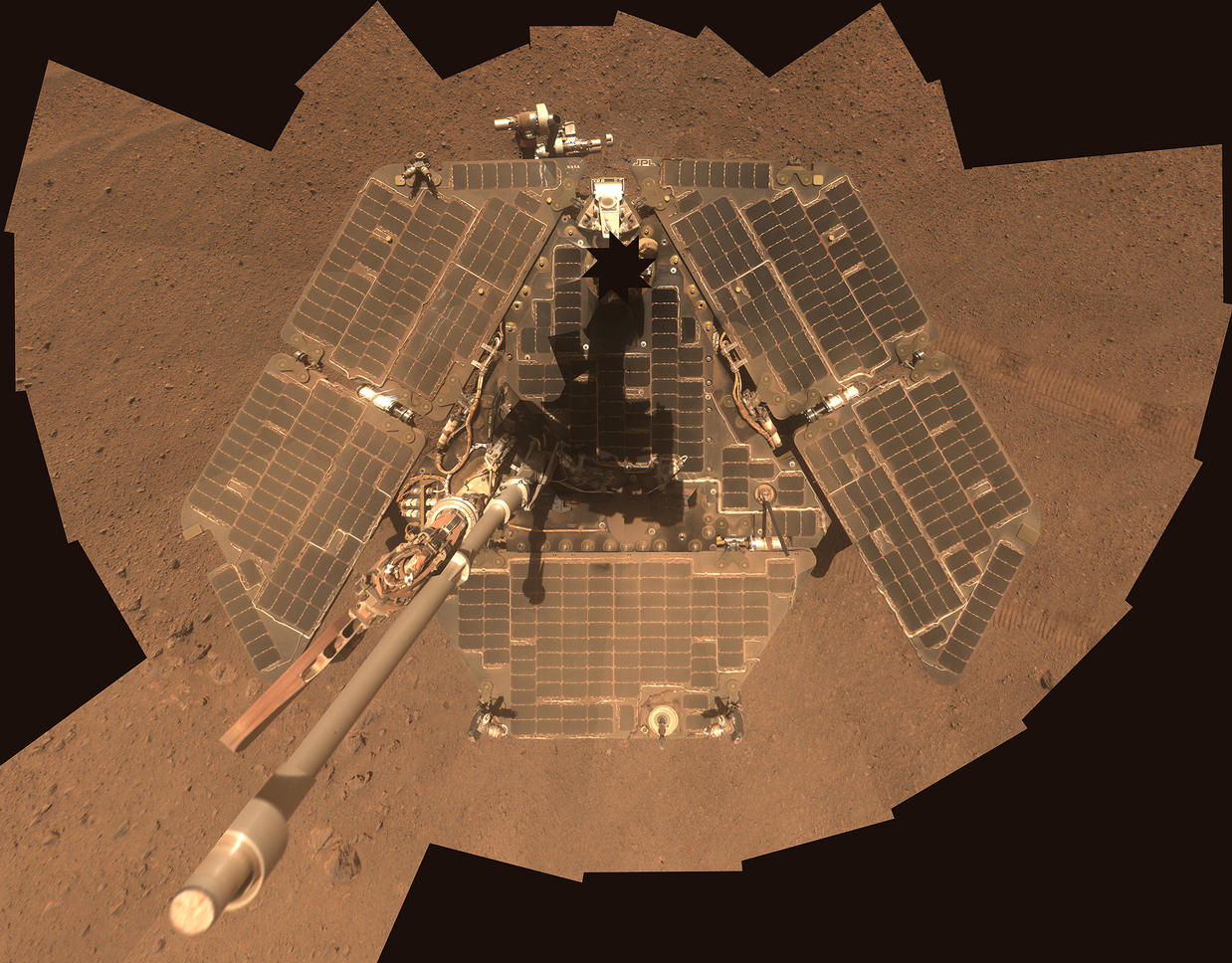
Self-Portrait by Opportunity Mars Rover in January 2014

NASA's Mars Exploration Rover Opportunity recorded the component images for this self-portrait about three weeks before completing a decade of work on Mars. The rover's panoramic camera (Pancam) took the images during the interval Jan. 3, 2014, to Jan. 6, 2014, a few days after winds removed some of the dust that had been accumulating on the rover's solar panels.
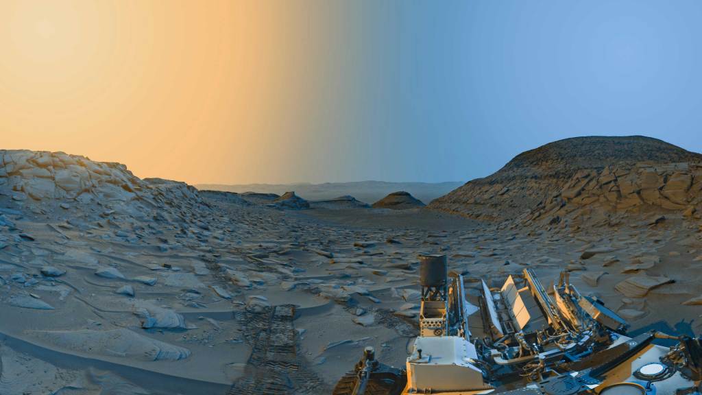
Opportunity landed on Mars on Jan. 25, 2004, Universal Time (Jan. 24, 2004, PST) for a mission that was planned to last three months. It is still active 10 Earth years later.

This image is presented as a vertical projection. The mast on which the Pancam is mounted does not appear in the image, though its shadow does.

Image Credit: NASA/JPL-Caltech/Cornell Univ./Arizona State Univ.


Browse Image | Full Resolution

Mineral Detected from Orbit Found in Dark Veneers

Researchers used NASA's Mars Exploration Rover Opportunity to find a water-related mineral on the ground that had been detected from orbit, and found it in the dark veneer of rocks on the rim of Endeavour Crater.

This false-color view from the panoramic camera (Pancam) on Opportunity shows a dark veneer, exposed after brushing with the rover's rock abrasion tool. These finely layered rocks with dark veneers are in the "Whitewater Lake" outcrop on "Matijevic Hill" on the western rim of Endeavour. The deposits are part of the ancient Matijevic formation, which predates the Endeavour impact event. The brushed area is about 1.5 inches (3.8 centimeters) wide. This image was taken on the 3,098th Martian day, or sol, of Opportunity's mission (Oct. 11, 2012).

An unannotated version of the image is available as Fig. 1.

Image credit: NASA/JPL-Caltech/Cornell Univ./Arizona State Univ.


Labeled
Browse Image | Full Resolution

Unlabeled
Browse Image | Full Resolution
'Cape York' Explored

A region known as "Cape York" on the western rim of Endeavour Crater, where NASA's Mars Exploration Rover Opportunity worked for 20 months, is highlighted in these images.

The inset at upper left is a portion of a false-color image taken by the High Resolution Imaging Science Experiment (HiRISE) camera on NASA's Mars Reconnaissance Orbiter. The black outline shows the "Matijevic Hill" region, enlarged in the central image. Initial traverses accomplished by Opportunity to evaluate the geologic setting of the region are noted. The Opportunity team was interested in this region because the Compact Reconnaissance Spectrometer for Mars (CRISM) on NASA's Mars Reconnaissance Orbiter showed a specific type of clay mineral called a ferric smectite. This type of clay mineral originally formed in groundwater along fractures in which the water was only mildly acidic.

The lower left inset shows a portion of CRISM data centered on Cape York. The red region delineates where CRISM spectra show features diagnostic of the smectite clay mineral.

This image is from a portion of a HiRISE observation catalogued as ESP_032573_1775 . Other products from the same observation are available at http://hirise.lpl.arizona.edu/ESP_032573_1775.

HiRISE is operated by the University of Arizona, Tucson. The instrument was built by Ball Aerospace & Technologies Corp., Boulder, Colo. CRISM was built and is operated by the Applied Physics Laboratory of Johns Hopkins University, Md. NASA's Mars Exploration Rover Project, Mars Reconnaissance Orbiter Project and Mars Science Laboratory Project are managed for NASA's Science Mission Directorate, Washington, by NASA's Jet Propulsion Laboratory, a division of the California Institute of Technology in Pasadena.

Image credit: NASA/JPL-Caltech/Univ. of Arizona

Browse Image | Full Resolution
'Esperance6' and 'Lihir' Rover Targets

This false-color view was taken by the panoramic camera (Pancam) on NASA's Mars Exploration Rover Opportunity on the 3,230th Martian day, or sol, of the rover's mission (Feb. 23, 2013). The rock targets known as "Esperance6," and "Lihir," are shown. Esperance6 was deeply abraded with the rover's rock abrasion tool. These rocks are part of the Matijevic formation located on "Matijevic Hill" on the rim of Endeavour Crater. The scene shown is approximately 27.6 inches (70 centimeters) across. An unlabeled image of these rocks is at http://photojournal.jpl.nasa.gov/catalog/PIA17074.

Image credit: NASA/JPL-Caltech/Cornell Univ./Arizona State Univ.


Browse Image | Full Resolution

Mineral Plot from 'Esperance' Target

This plot shows how planetary geologists are narrowing in on the composition of a rock target on Mars, known as "Esperance," located in a fracture that cuts through the Matijevic formation on the "Matijevic Hill" region on the western rim of Endeavour Crater. The plot segregates various minerals examined by NASA's Mars Exploration Rover Opportunity according to their different compositions; for example, those with more iron and magnesium oxides are located in the lower right corner.

Opportunity's examination of the Esperance rock used the rover's rock abrasion tool to sequentially grind deeper and deeper into the target, with intervening compositional measurements. The measured samples are closest on this plot to a known mineral called montmorillonite, which belongs to the smectite clay family. Montmorillonite has more aluminum than other clays. Its presence indicates that substantial groundwater flowed through the fracture and was only mildy acidic as well as reducing, meaning the mineral donates electrons to other chemicals.

Image credit: NASA/JPL-Caltech/Washington Univ. in St. Louis


Browse Image | Full Resolution

Opportunity's First Decade of Driving on Mars

NASA's Mars Exploration Rover Opportunity has been working on Mars since landing inside Eagle Crater on Jan. 25, 2004 (Universal Time; evening of Jan. 24, Pacific Standard Time). The gold line on this image shows Opportunity's route from the landing site, in upper left, to the area it is investigating on the western rim of Endeavour Crater as of the rover's 10th anniversary on Mars, in Earth years.

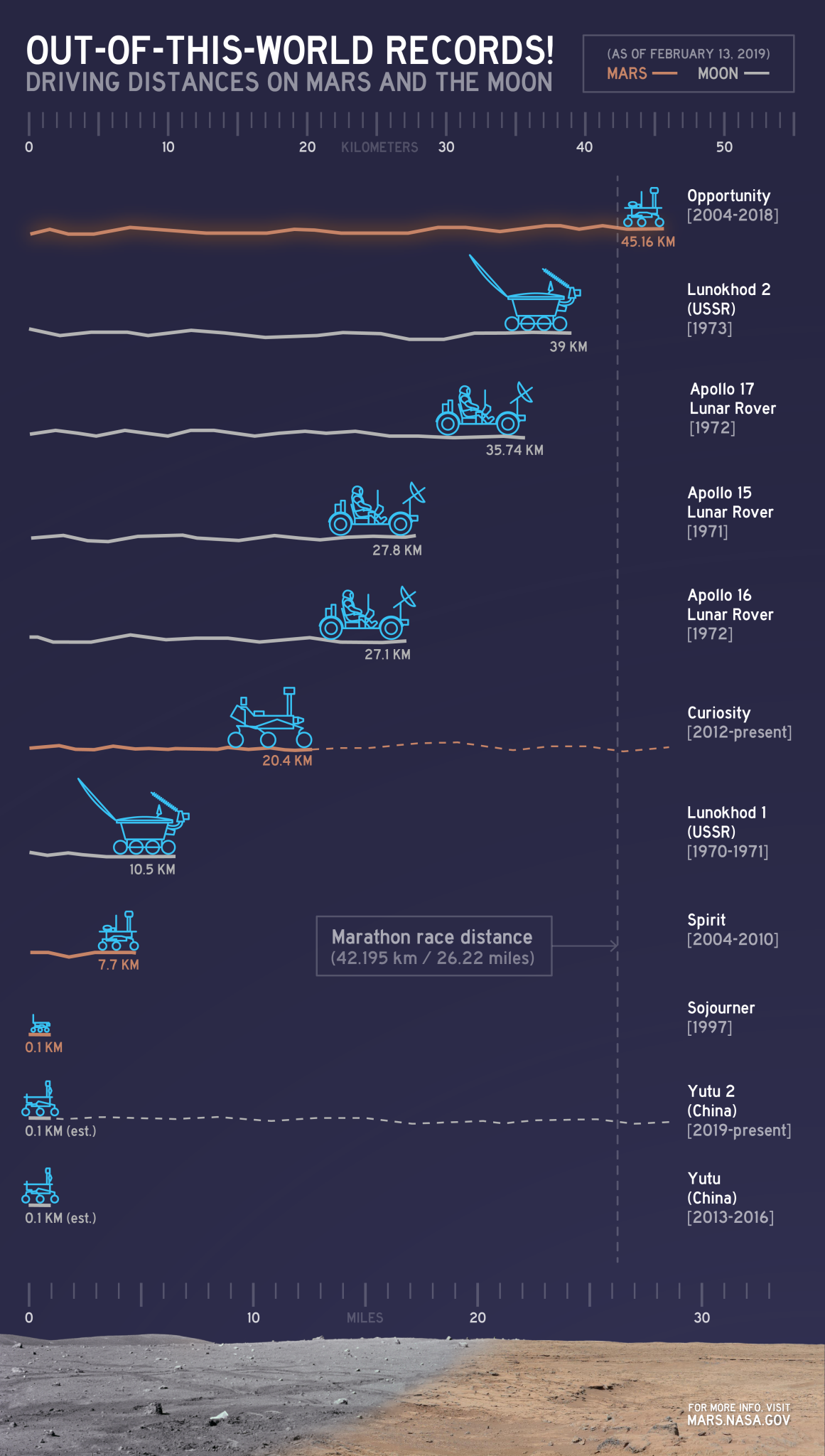
In its first decade of driving on Mars, Opportunity covered a total of 24.07 miles (38.73 kilometers). In early 2014, Opportunity is ascending "Murray Ridge" above "Solander Point" on the rim of Endeavour Crater. A destination ahead, if the rover keeps working, is the "Cape Tribulation" section farther south on Endeavour's rim.

The features are all within the Meridiani Planum region of equatorial Mars, which was chosen as Opportunity's landing area because of earlier detection of the mineral hematite from orbit.

The base image for the map is a mosaic of images taken by the Context Camera on NASA's Mars Reconnaissance Orbiter. The 5-kilometer scale bar is 3.1 miles long, and the diameter of Endeavour Crater is about 14 miles (22 kilometers). North is up.

Opportunity completed its three-month prime mission in April 2004 and has continued operations in bonus extended missions. It has found several types of evidence of ancient environments with abundant liquid water. The Mars Reconnaissance Orbiter reached Mars in 2006, completed its prime mission in 2010, and is also working in an extended mission.

This traverse map was made at the New Mexico Museum of Natural History & Science, Albuquerque. NASA's Jet Propulsion Laboratory, a division of the California Institute of Technology in Pasadena, manages the Mars Exploration Rover Project and the Mars Reconnaissance Orbiter for the NASA Science Mission Directorate, Washington. Malin Space Science Systems, San Diego, built and operates the orbiter's Context Camera.

Image Credit: NASA/JPL-Caltech/MSSS/NMMNHS


Browse Image | Full Resolution

NASA's Mars Rover Spirit's View Southward from Husband Hill

This section from a panorama that NASA's Mars Exploration Rover Spirit acquired in October 2005 from the top of "Husband Hill" presents the view toward the south from that summit. The entire 360-degree vista from Spirit's panoramic camera (Pancam) is available at http://photojournal.jpl.nasa.gov/catalog/PIA03095 .

After climbing Husband Hill, Spirit spent more than four years exploring locations within this view, including the "Comanche" outcrop and the "Home Plate" area. At Comanche, the rover found carbonate minerals, evidence of an ancient wet environment that was not acidic, and also a clue that some of the carbon dioxide in Mars' original atmosphere may have been converted to carbonates. Near Home Plate, Spirit found a deposit of nearly pure silica, evidence of an ancient environment of hot springs or steam vents.

The summit of Husband Hill is a broad plateau of rock outcrops and windblown drifts about 100 meters (300 feet) higher than the surrounding plains of Gusev Crater, where Spirit landed in January 2004.

This approximately true-color scene combines images taken through three different Pancam color filters, centered on wavelengths of 750 nanometers, 530 nanometers and 430 nanometers.
Image Credit: NASA/JPL-Caltech/Cornell Univ.

Browse Image | Full Resolution

 
Diverse Outcrops on 'Matijevic Hill'

NASA's Mars Exploration Rover Opportunity used its panoramic camera (Pancam) to capture this false-color panorama of the "Matijevic Hill" area on the "Cape York" segment of the western rim of Endeavour Crater. Some of the outcrops that the rover examined are labeled. The breccias are jumbled rocks amalgamated together, interpreted at this site as material tossed by the impact that excavated the crater.

The component images for this scene were taken during the interval Nov. 19, 2012, through Dec. 3, 2012. Unannotated versions of this panorama, in false color, approximately true color and stereo, are at http://photojournal.jpl.nasa.gov/catalog/PIA16704, http://photojournal.jpl.nasa.gov/catalog/PIA16703 and http://photojournal.jpl.nasa.gov/catalog/PIA16709.

Image Credit: NASA/JPL-Caltech/Cornell Univ./Arizona State Univ.


Browse Image | Full Resolution

JPL Image Use Policy

USA.gov
PRIVACY   I   IMAGE POLICY   I   FAQ   I   SITEMAP   I   CREDITS