Jet Propulsion Laboratory California Institute of Technology Follow this link to skip to the main content
Images
Press Release Images
Spirit
Opportunity
All Raw Images
Spirit
Opportunity
Panoramas
Spirit
Opportunity
3-D Images
Spirit
Opportunity
Spacecraft
Mars Artwork
Landing Sites
Press Release Images: Spirit
21-Oct-2005
 
 
This mosaic of images shows a sandy, relatively flat expanse of hilltop flanked by a layered rock outcrop on the left and a rocky slope topped by a crest of sand on the right. Beyond the flat surface in the middle are two more hills sloping to the right. Beyond them, in the distance, is a mostly flat horizon except for a ridge in the middle that marks the edge of Gusev Crater. A twin pair of wheel tracks approaches from beyond a low ridge slightly to the right of the center of the panorama. The tracks then veer to the right and make a circle where the rover turned completely around and headed off to the left. On the far left, the tracks go up an embankment and retrace themselves down again, where they form another circle where the rover turned completely around and returned to the center of the panorama. The tracks then disappear off the bottom edge of the panorama. The front edge of the rover's solar panels can be seen in the bottom right corner of the panorama.
Looking Back at Spirit's Trail to the Summit

Before moving on to explore more of Mars, NASA's Mars Exploration Rover Spirit looked back at the long and winding trail of twin wheel tracks the rover created to get to the top of "Husband Hill." Spirit spent several days in October 2005 at this location, perched on a lofty, rock-strewn incline next to a precarious outcrop nicknamed "Hillary." Researchers helped the rover make several wheel adjustments to get solid footing before conducting scientific analysis of the rock outcrop. The rock turned out to be similar in appearance and composition to a rock target called "Jibsheet" that the rover had studied several months earlier and hundreds of meters away.

To the west are the slopes of the "Columbia Hills," so named for the astronauts of the Space Shuttle Columbia. Beyond the hills are the flat plains and rim of Gusev Crater.

Spirit took this 360-degree panorama of images with its navigation camera on the 627th Martian day, or sol, (Oct. 7, 2005) of its exploration of Gusev Crater on Mars. This view is presented in a cylindrical projection with geometric seam correction.
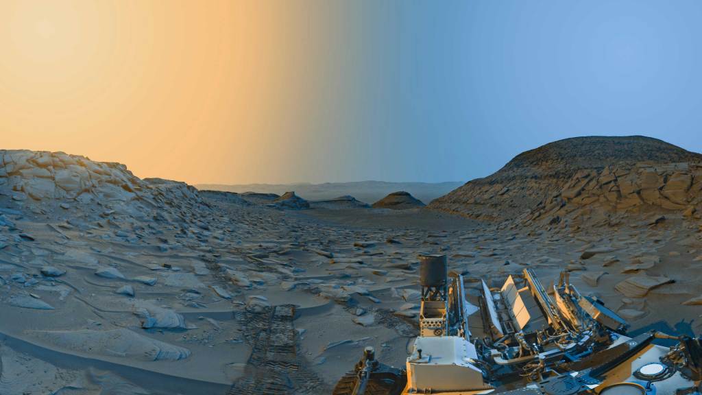
Image credit: NASA/JPL-Caltech
Browse Image | Medium Image (167 kB) | Large (3.4 MB)
 
This mosaic of images shows a sandy, relatively flat expanse of hilltop flanked by a layered rock outcrop on the left and a rocky slope topped by a crest of sand on the right. Beyond the flat surface in the middle are two more hills sloping to the right. Beyond them, in the distance, is a mostly flat horizon except for a ridge in the middle that marks the edge of Gusev Crater. A twin pair of wheel tracks approaches from beyond a low ridge slightly to the right of the center of the panorama. The tracks then veer to the right and make a circle where the rover turned completely around and headed off to the left. On the far left, the tracks go up an embankment and retrace themselves down again, where they form another circle where the rover turned completely around and returned to the center of the panorama. The tracks then disappear off the bottom edge of the panorama. The front edge of the rover's solar panels can be seen in the bottom right corner of the panorama.
Looking Back at Spirit's Trail to the Summit (Stereo)

Before moving on to explore more of Mars, NASA's Mars Exploration Rover Spirit looked back at the long and winding trail of twin wheel tracks the rover created to get to the top of "Husband Hill." Spirit spent several days in October 2005 at this location, perched on a lofty, rock-strewn incline next to a precarious outcrop nicknamed "Hillary." Researchers helped the rover make several wheel adjustments to get solid footing before conducting scientific analysis of the rock outcrop. The rock turned out to be similar in appearance and composition to a rock target called "Jibsheet" that the rover had studied several months earlier and hundreds of meters away.

To the west are the slopes of the "Columbia Hills," so named for the astronauts of the Space Shuttle Columbia. Beyond the hills are the flat plains and rim of Gusev Crater.

Spirit took this 360-degree panorama of images with its navigation camera on the 627th Martian day, or sol, (Oct. 7, 2005) of its exploration of Gusev Crater on Mars. This stereo view is presented in a cylindrical-perspective projection with geometric seam correction.

Image credit: NASA/JPL-Caltech
Browse Image | Medium Image (197 kB) | Large (7.4 MB)
 
This mosaic of images shows a sandy, relatively flat expanse of hilltop flanked by a layered rock outcrop on the left and a rocky slope topped by a crest of sand on the right. Beyond the flat surface in the middle are two more hills sloping to the right. Beyond them, in the distance, is a mostly flat horizon except for a ridge in the middle that marks the edge of Gusev Crater. A twin pair of wheel tracks approaches from beyond a low ridge slightly to the right of the center of the panorama. The tracks then veer to the right and make a circle where the rover turned completely around and headed off to the left. On the far left, the tracks go up an embankment and retrace themselves down again, where they form another circle where the rover turned completely around and returned to the center of the panorama. The tracks then disappear off the bottom edge of the panorama. The front edge of the rover's solar panels can be seen in the bottom right corner of the panorama.
Looking Back at Spirit's Trail to the Summit (Left Eye)

Before moving on to explore more of Mars, NASA's Mars Exploration Rover Spirit looked back at the long and winding trail of twin wheel tracks the rover created to get to the top of "Husband Hill." Spirit spent several days in October 2005 at this location, perched on a lofty, rock-strewn incline next to a precarious outcrop nicknamed "Hillary." Researchers helped the rover make several wheel adjustments to get solid footing before conducting scientific analysis of the rock outcrop. The rock turned out to be similar in appearance and composition to a rock target called "Jibsheet" that the rover had studied several months earlier and hundreds of meters away.

To the west are the slopes of the "Columbia Hills," so named for the astronauts of the Space Shuttle Columbia. Beyond the hills are the flat plains and rim of Gusev Crater.

Spirit took this 360-degree panorama of images with its navigation camera on the 627th Martian day, or sol, (Oct. 7, 2005) of its exploration of Gusev Crater on Mars. This view is the left-eye member of a stereo pair presented in a cylindrical-perspective projection with geometric seam correction.

Image credit: NASA/JPL-Caltech
Browse Image | Medium Image (189 kB) | Large (3.9 MB)
 
This mosaic of images shows a sandy, relatively flat expanse of hilltop flanked by a layered rock outcrop on the left and a rocky slope topped by a crest of sand on the right. Beyond the flat surface in the middle are two more hills sloping to the right. Beyond them, in the distance, is a mostly flat horizon except for a ridge in the middle that marks the edge of Gusev Crater. A twin pair of wheel tracks approaches from beyond a low ridge slightly to the right of the center of the panorama. The tracks then veer to the right and make a circle where the rover turned completely around and headed off to the left. On the far left, the tracks go up an embankment and retrace themselves down again, where they form another circle where the rover turned completely around and returned to the center of the panorama. The tracks then disappear off the bottom edge of the panorama. The front edge of the rover's solar panels can be seen in the bottom right corner of the panorama.
Looking Back at Spirit's Trail to the Summit (Right Eye)

Before moving on to explore more of Mars, NASA's Mars Exploration Rover Spirit looked back at the long and winding trail of twin wheel tracks the rover created to get to the top of "Husband Hill." Spirit spent several days in October 2005 at this location, perched on a lofty, rock-strewn incline next to a precarious outcrop nicknamed "Hillary." Researchers helped the rover make several wheel adjustments to get solid footing before conducting scientific analysis of the rock outcrop. The rock turned out to be similar in appearance and composition to a rock target called "Jibsheet" that the rover had studied several months earlier and hundreds of meters away.

To the west are the slopes of the "Columbia Hills," so named for the astronauts of the Space Shuttle Columbia. Beyond the hills are the flat plains and rim of Gusev Crater.

Spirit took this 360-degree panorama of images with its navigation camera on the 627th Martian day, or sol, (Oct. 7, 2005) of its exploration of Gusev Crater on Mars. This view is the right-eye member of a stereo pair presented in a cylindrical-perspective projection with geometric seam correction.
Image credit: NASA/JPL-Caltech
Browse Image | Medium Image (180 kB) | Large (3.8 MB)
This mosaic of images shows a sandy, relatively flat expanse of hilltop flanked by a layered rock outcrop on the left and a rocky slope topped by a crest of sand on the right. Beyond the flat surface in the middle are two more hills sloping to the right. Beyond them, in the distance, is a mostly flat horizon except for a ridge in the middle that marks the edge of Gusev Crater. A twin pair of wheel tracks approaches from beyond a low ridge slightly to the right of the center of the panorama. The tracks then veer to the right and make a circle where the rover turned completely around and headed off to the left. On the far left, the tracks go up an embankment and retrace themselves down again, where they form another circle where the rover turned completely around and returned to the center of the panorama. The tracks then disappear off the bottom edge of the panorama. The front edge of the rover's solar panels can be seen in the bottom right corner of the panorama.
Looking Back at Spirit's Trail to the Summit (Polar)

Before moving on to explore more of Mars, NASA's Mars Exploration Rover Spirit looked back at the long and winding trail of twin wheel tracks the rover created to get to the top of "Husband Hill." Spirit spent several days in October 2005 at this location, perched on a lofty, rock-strewn incline next to a precarious outcrop nicknamed "Hillary." Researchers helped the rover make several wheel adjustments to get solid footing before conducting scientific analysis of the rock outcrop. The rock turned out to be similar in appearance and composition to a rock target called "Jibsheet" that the rover had studied several months earlier and hundreds of meters away.

To the west are the slopes of the "Columbia Hills," so named for the astronauts of the Space Shuttle Columbia. Beyond the hills are the flat plains and rim of Gusev Crater.

Spirit took this 360-degree panorama of images with its navigation camera on the 627th Martian day, or sol, (Oct. 7, 2005) of its exploration of Gusev Crater on Mars. This view is presented in a polar projection with geometric seam correction.
Image credit: NASA/JPL-Caltech
Browse Image | Medium Image (89 kB) | Large (4.4 MB)
This mosaic of images shows a sandy, relatively flat expanse of hilltop flanked by a layered rock outcrop on the left and a rocky slope topped by a crest of sand on the right. Beyond the flat surface in the middle are two more hills sloping to the right. Beyond them, in the distance, is a mostly flat horizon except for a ridge in the middle that marks the edge of Gusev Crater. A twin pair of wheel tracks approaches from beyond a low ridge slightly to the right of the center of the panorama. The tracks then veer to the right and make a circle where the rover turned completely around and headed off to the left. On the far left, the tracks go up an embankment and retrace themselves down again, where they form another circle where the rover turned completely around and returned to the center of the panorama. The tracks then disappear off the bottom edge of the panorama. The front edge of the rover's solar panels can be seen in the bottom right corner of the panorama.
Looking Back at Spirit's Trail to the Summit (Vertical)

Before moving on to explore more of Mars, NASA's Mars Exploration Rover Spirit looked back at the long and winding trail of twin wheel tracks the rover created to get to the top of "Husband Hill." Spirit spent several days in October 2005 at this location, perched on a lofty, rock-strewn incline next to a precarious outcrop nicknamed "Hillary." Researchers helped the rover make several wheel adjustments to get solid footing before conducting scientific analysis of the rock outcrop. The rock turned out to be similar in appearance and composition to a rock target called "Jibsheet" that the rover had studied several months earlier and hundreds of meters away.

To the west are the slopes of the "Columbia Hills," so named for the astronauts of the Space Shuttle Columbia. Beyond the hills are the flat plains and rim of Gusev Crater.

Spirit took this 360-degree panorama of images with its navigation camera on the 627th Martian day, or sol, (Oct. 7, 2005) of its exploration of Gusev Crater on Mars. This view is presented in a vertical projection with geometric seam correction.

Image credit: NASA/JPL-Caltech
Browse Image | Medium Image (74 kB) | Large (4.6 MB)
 
This black-and-white mosaic of images shows a east-northeastward view of Gusev Crater from the flank of 'Husband Hill.' In the lower left corner is part of one of the rover's solar panels beneath a rock-strewn ridge capped by sand drifts that heads off to the right. The same ridge becomes steeper as it continues farther to the right, dropping off into a basin on the left side that makes up the top center of the mosaic.  Beyond the ridge is a mostly flat horizon where the plains of Gusev Crater meet a clear Martian sky.
After Conquering 'Husband Hill,' Spirit Moves On

The first explorer ever to scale a summit on another planet, NASA's Mars Exploration Rover Spirit has begun a long trek downward from the top of "Husband Hill" to new destinations. As shown in this 180-degree panorama from east of the summit, Spirit's earlier tracks are no longer visible. They are off to the west (to the left in this view). Spirit's next destination is "Haskin Ridge," straight ahead along the edge of the steep cliff on the right side of this panorama.

The scene is a mosaic of images that Spirit took with the navigation camera on the rover's 635th Martian day, or sol, (Oct. 16, 2005) of exploration of Gusev Crater on Mars. This view is presented in a cylindrical projection with geometric seam correction.
Image credit: NASA/JPL-Caltech
Browse Image | Medium Image (234 kB) | Large (1.7 MB)
 
This black-and-white mosaic of images shows a east-northeastward view of Gusev Crater from the flank of 'Husband Hill.' In the lower left corner is part of one of the rover's solar panels beneath a rock-strewn ridge capped by sand drifts that heads off to the right. The same ridge becomes steeper as it continues farther to the right, dropping off into a basin on the left side that makes up the top center of the mosaic.  Beyond the ridge is a mostly flat horizon where the plains of Gusev Crater meet a clear Martian sky.
After Conquering 'Husband Hill,' Spirit Moves On (Stereo)

The first explorer ever to scale a summit on another planet, NASA's Mars Exploration Rover Spirit has begun a long trek downward from the top of "Husband Hill" to new destinations. As shown in this 180-degree panorama from east of the summit, Spirit's earlier tracks are no longer visible. They are off to the west (to the left in this view). Spirit's next destination is "Haskin Ridge," straight ahead along the edge of the steep cliff on the right side of this panorama.

The scene is a mosaic of images that Spirit took with the navigation camera on the rover's 635th Martian day, or sol, (Oct. 16, 2005) of exploration of Gusev Crater on Mars. This stereo view is presented in a cylindrical-perspective projection with geometric seam correction.

Image credit: NASA/JPL-Caltech
Browse Image | Medium Image (262 kB) | Large (3.2 MB)
 
This black-and-white mosaic of images shows a east-northeastward view of Gusev Crater from the flank of 'Husband Hill.' In the lower left corner is part of one of the rover's solar panels beneath a rock-strewn ridge capped by sand drifts that heads off to the right. The same ridge becomes steeper as it continues farther to the right, dropping off into a basin on the left side that makes up the top center of the mosaic.  Beyond the ridge is a mostly flat horizon where the plains of Gusev Crater meet a clear Martian sky.
After Conquering 'Husband Hill,' Spirit Moves On (Left Eye)

The first explorer ever to scale a summit on another planet, NASA's Mars Exploration Rover Spirit has begun a long trek downward from the top of "Husband Hill" to new destinations. As shown in this 180-degree panorama from east of the summit, Spirit's earlier tracks are no longer visible. They are off to the west (to the left in this view). Spirit's next destination is "Haskin Ridge," straight ahead along the edge of the steep cliff on the right side of this panorama.

The scene is a mosaic of images that Spirit took with the navigation camera on the rover's 635th Martian day, or sol, (Oct. 16, 2005) of exploration of Gusev Crater on Mars. This view is the left-eye member of a stereo pair presented in a cylindrical-perspective projection with geometric seam correction.

Image credit: NASA/JPL-Caltech
Browse Image | Medium Image (224 kB) | Large (1.8 MB)
 
This black-and-white mosaic of images shows a east-northeastward view of Gusev Crater from the flank of 'Husband Hill.' In the lower left corner is part of one of the rover's solar panels beneath a rock-strewn ridge capped by sand drifts that heads off to the right. The same ridge becomes steeper as it continues farther to the right, dropping off into a basin on the left side that makes up the top center of the mosaic.  Beyond the ridge is a mostly flat horizon where the plains of Gusev Crater meet a clear Martian sky.
After Conquering 'Husband Hill,' Spirit Moves On (Right Eye)

The first explorer ever to scale a summit on another planet, NASA's Mars Exploration Rover Spirit has begun a long trek downward from the top of "Husband Hill" to new destinations. As shown in this 180-degree panorama from east of the summit, Spirit's earlier tracks are no longer visible. They are off to the west (to the left in this view). Spirit's next destination is "Haskin Ridge," straight ahead along the edge of the steep cliff on the right side of this panorama.

The scene is a mosaic of images that Spirit took with the navigation camera on the rover's 635th Martian day, or sol, (Oct. 16, 2005) of exploration of Gusev Crater on Mars. This view is the right-eye member of a stereo pair presented in a cylindrical-perspective projection with geometric seam correction.

Image credit: NASA/JPL-Caltech
Browse Image | Medium Image (215 kB) | Large (1.7 MB)
This black-and-white mosaic of images shows a east-northeastward view of Gusev Crater from the flank of 'Husband Hill.' In the lower left corner is part of one of the rover's solar panels beneath a rock-strewn ridge capped by sand drifts that heads off to the right. The same ridge becomes steeper as it continues farther to the right, dropping off into a basin on the left side that makes up the top center of the mosaic.  Beyond the ridge is a mostly flat horizon where the plains of Gusev Crater meet a clear Martian sky.
After Conquering 'Husband Hill,' Spirit Moves On (Polar)

The first explorer ever to scale a summit on another planet, NASA's Mars Exploration Rover Spirit has begun a long trek downward from the top of "Husband Hill" to new destinations. As shown in this 180-degree panorama from east of the summit, Spirit's earlier tracks are no longer visible. They are off to the west (to the left in this view). Spirit's next destination is "Haskin Ridge," straight ahead along the edge of the steep cliff on the right side of this panorama.

The scene is a mosaic of images that Spirit took with the navigation camera on the rover's 635th Martian day, or sol, (Oct. 16, 2005) of exploration of Gusev Crater on Mars. This view is presented in a polar projection with geometric seam correction.

Image credit: NASA/JPL-Caltech
Browse Image | Medium Image (90 kB) | Large (3.3 MB)
This black-and-white mosaic of images shows a east-northeastward view of Gusev Crater from the flank of 'Husband Hill.' In the lower left corner is part of one of the rover's solar panels beneath a rock-strewn ridge capped by sand drifts that heads off to the right. The same ridge becomes steeper as it continues farther to the right, dropping off into a basin on the left side that makes up the top center of the mosaic.  Beyond the ridge is a mostly flat horizon where the plains of Gusev Crater meet a clear Martian sky.
After Conquering 'Husband Hill,' Spirit Moves On (Vertical)

The first explorer ever to scale a summit on another planet, NASA's Mars Exploration Rover Spirit has begun a long trek downward from the top of "Husband Hill" to new destinations. As shown in this 180-degree panorama from east of the summit, Spirit's earlier tracks are no longer visible. They are off to the west (to the left in this view). Spirit's next destination is "Haskin Ridge," straight ahead along the edge of the steep cliff on the right side of this panorama.

The scene is a mosaic of images that Spirit took with the navigation camera on the rover's 635th Martian day, or sol, (Oct. 16, 2005) of exploration of Gusev Crater on Mars. This view is presented in a vertical projection with geometric seam correction.

Image credit: NASA/JPL-Caltech
Browse Image | Medium Image (100 kB) | Large (1.1 MB)
 
This image shows four frames in a row. The far left frame shows a white line outlining the constellation Orion, shaped rather like an hourglass, though in mythology, the stars on the right represent a bow and arrow poised to shoot and the other stars represent the body of the archer Orion. The stars of the constellation are labelled. On the upper left is the bright star Rigel; to the right of it is Saiph. In the lower left corner is the star Bellatrix. In the middle of the image is a horizontal line of three stars labeled 'Orion's Belt.' Above the belt are the stars and gas clouds of the Orion Nebula. The three frames to the right of the first frame show the same stars without the labels through a background that becomes increasingly hazier from left to right. Diagonal streaks representing the relative motion of the stars as viewed on Mars become increasingly apparent from left to right as well. The images represent exposures  of 10 seconds, 30 seconds, and 60 seconds, respectively.
Stargazing at 'Husband Hill Observatory' on Mars

NASA's Mars Exploration Rover Spirit continues to take advantage of extra solar energy by occasionally turning its cameras upward for night sky observations. Most recently, Spirit made a series of observations of bright star fields from the summit of "Husband Hill" in Gusev Crater on Mars. Scientists use the images to assess the cameras' sensitivity and to search for evidence of nighttime clouds or haze. The image on the left is a computer simulation of the stars in the constellation Orion. The next three images are actual views of Orion captured with Spirit's panoramic camera during exposures of 10, 30, and 60 seconds.

Because Spirit is in the southern hemisphere of Mars, Orion appears upside down compared to how it would appear to viewers in the Northern Hemisphere of Earth. "Star trails" in the longer exposures are a result of the planet's rotation. The faintest stars visible in the 60-second exposure are about as bright as the faintest stars visible with the naked eye from Earth (about magnitude 6 in astronomical terms). The Orion Nebula, famous as a nursery of newly forming stars, is also visible in these images. Bright streaks in some parts of the images aren't stars or meteors or unidentified flying objects, but are caused by solar and galactic cosmic rays striking the camera's detector.

Spirit acquired these images with the panoramic camera on Martian day, or sol, 632 (Oct. 13, 2005) at around 45 minutes past midnight local time, using the camera's broadband filter (wavelengths of 739 nanometers plus or minus 338 nanometers).

Image credit: NASA/JPL-Caltech/Cornell/Texas A&M/Space Science Institute
Browse Image | Medium Image (80 kB) | Large (720 kB)

JPL Image Use Policy

USA.gov
PRIVACY   I   IMAGE POLICY   I   FAQ   I   SITEMAP   I   CREDITS