|
 |
Press Release Images: Opportunity |
 |
 |
02-Mar-2004
|
Opportunity Rover Finds Strong Evidence Meridiani Planum Was Wet
Full Press Release
|
|
 |
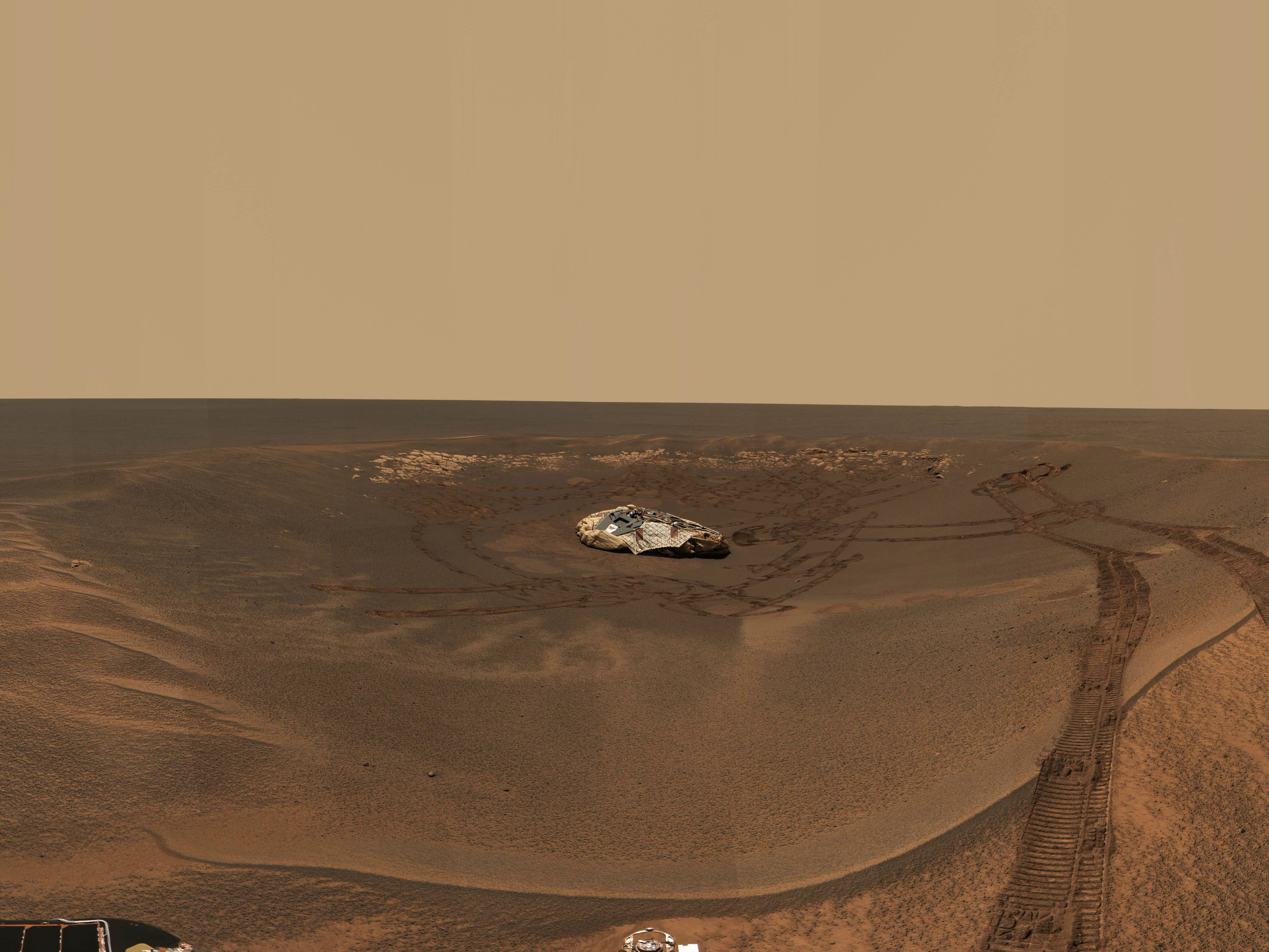
Opportunity Landing Spot Panorama (3-D Model)
The rocky outcrop traversed by the Mars Exploration Rover Opportunity is visible in this three-dimensional model of the rover's landing site. Opportunity has acquired close-up images along the way, and scientists are using the rover's instruments to closely examine portions of interest. The white fragments that look crumpled near the center of the image are portions of the airbags. Distant scenery is displayed on a spherical backdrop or "billboard" for context. Artifacts near the top rim of the crater are a result of the transition between the three-dimensional model and the billboard. Portions of the terrain model lacking sufficient data appear as blank spaces or gaps, colored reddish-brown for better viewing. This image was generated using special software from NASA's Ames Research Center and a mosaic of images taken by the rover's panoramic camera.
Image Credit: NASA/JPL/Ames/Cornell
|
Browse Image (41 kB) |
Large (1.6 MB)
|
|
|
 |
A Treasure Trove of Martian Rocks
This high-resolution image captured by the Mars Exploration Rover Opportunity's panoramic camera highlights the puzzling rock outcrop near the rover's landing site. Opportunity has been investigating the outcrop with the suite of scientific instruments located on its robotic arm. These layered rocks measure only 10 centimeters (4 inches) tall, about the height of a street curb. Data from the panoramic camera's near-infrared, blue and green filters were combined to create this approximate, true-color image. This same image was previously released on Jan. 28, 2004 (PIA05163).
Image credit: NASA/JPL/Cornell
|
Browse Image |
Medium Image (225 kB) |
Large (4 MB)
|
|
 |
"El Capitan's" Scientific Gems
This mosaic of images taken by the panoramic camera onboard the Mars Exploration Rover Opportunity shows the rock region dubbed "El Capitan," which lies within the larger outcrop near the rover's landing site. "El Capitan" is being studied in great detail using the scientific instruments on the rover's arm; images from the panoramic camera help scientists choose the locations for this compositional work. The millimeter-scale detail of the lamination covering these rocks can be seen. The face of the rock to the right of the mosaic may be a future target for grinding with the rover's rock abrasion tool.
Image credit: NASA/JPL/Cornell
|
Browse Image |
Medium Image (114 kB) |
Large (1.3 MB)
|
|
 |
History Leaves Salts Behind
These plots, or spectra, show that a rock dubbed "McKittrick" near the Mars Exploration Rover Opportunity's landing site at Meridiani Planum, Mars, has higher concentrations of sulfur and bromine than a nearby patch of soil nicknamed "Tarmac." These data were taken by Opportunity's alpha particle X-ray spectrometer, which uses curium-244 to assess the elemental composition of rocks and soil. Only portions of the targets' full spectra are shown to highlight the significant differences in elemental concentrations between "McKittrick" and "Tarmac." Intensities are plotted on a logarithmic scale.
A nearby rock named Guadalupe similarly has extremely high concentrations of sulfur, but very little bromine. This "element fractionation" typically occurs when a watery brine slowly evaporates and various salt compounds are precipitated in sequence.
Image credit: NASA/JPL/Cornell/Max Planck Institute
|
Browse Image (36 kB) |
Large (201 kB)
|
|
 |
"McKittrick" Rich in Sulfur
These plots, or spectra, show that a rock dubbed "McKittrick" near the Mars Exploration Rover Opportunity's landing site at Meridiani Planum, Mars, possesses the highest concentration of sulfur yet observed on Mars. These data were acquired with the rover's alpha particle X-ray spectrometer, which produces a spectrum, or fingerprint, of chemicals in martian rocks and soil. This instrument contains a radioisotope, curium-244, that bombards a designated area with alpha particles and X-rays, causing a cascade of reflective fluorescent X-rays. The energies of these fluorescent X-rays are unique to each atom in the periodic table, allowing scientists to determine a target's elemental composition.
The spectra shown here are taken from "McKittrick" and a soil patch nicknamed "Tarmac," both of which are located within the small crater where Opportunity landed. "McKittrick" measurements were acquired after the rover drilled a hole in the rock with its rock abrasion tool. Only portions of the targets' full spectra are displayed. The data are expressed as X-ray intensity (linear scale) versus energy. The measured area is 28 millimeters (1 inch) in diameter.
When comparing two spectra, the relative intensities at a given energy are proportional to the elemental concentrations, however these proportionality factors can be complex. To be precise, scientists extensively calibrate the instrument using well-analyzed geochemical standards.
Both the alpha particle X-ray spectrometer and the rock abrasion tool are located on the rover's instrument deployment device, or arm.
Image credit: NASA/JPL/Cornell/Max Planck Institute
|
Browse Image (33 kB) |
Large (148 kB)
|
|
 |
Salty Martian Rock
These plots, or spectra, show that a rock dubbed "McKittrick" near the Mars Exploration Rover Opportunity's landing site at Meridiani Planum, Mars, has higher concentrations of sulfur and bromine than a nearby patch of soil nicknamed "Tarmac." These data were taken by Opportunity's alpha particle X-ray spectrometer, which produces a spectrum, or fingerprint, of chemicals in martian rocks and soil. The instrument contains a radioisotope, curium-244, that bombards a designated area with alpha particles and X-rays, causing a cascade of reflective fluorescent X-rays. The energies of these fluorescent X-rays are unique to each atom in the periodic table, allowing scientists to determine a target's chemical composition.
Both "Tarmac" and "McKittrick" are located within the small crater where Opportunity landed. The full spectra are expressed as X-ray intensity (logarithmic scale) versus energy. When comparing two spectra, the relative intensities at a given energy are proportional to the elemental concentrations, however these proportionality factors can be complex. To be precise, scientists extensively calibrate the instrument using well-analyzed geochemical standards.
Both the alpha particle X-ray spectrometer and the rock abrasion tool are located on the rover's instrument deployment device, or arm.
Image credit: NASA/JPL/Cornell/Max Planck Institute
|
Browse Image (42 kB) |
Large (220 kB)
|
|
 |
Mineral Tells Tale of Watery Past
This spectrum, taken by the Mars Exploration Rover Opportunity's Moessbauer spectrometer, shows the presence of an iron-bearing mineral called jarosite in the collection of rocks dubbed "El Capitan." "El Capitan" is located within the rock outcrop that lines the inner edge of the small crater where Opportunity landed. The pair of yellow peaks specifically indicates a jarosite phase, which contains water in the form of hydroxyl as a part of its structure. These data suggest water-driven processes exist on Mars. Three other phases are also identified in this spectrum: a magnetic phase (blue), attributed to an iron-oxide mineral; a silicate phase (green), indicative of minerals containing double-ionized iron (Fe 2+); and a third phase (red) of minerals with triple-ionized iron (Fe 3+).
Image credit: NASA/JPL/University of Mainz
|
Browse Image (26 kB) |
Large (101 kB)
|
|
 |
Mineral Tells Tale of Watery Past-2
This spectrum, taken by the Mars Exploration Rover Opportunity's Moessbauer spectrometer, shows the presence of an iron-bearing mineral called jarosite in the collection of rocks dubbed "El Capitan." "El Capitan" is located within the outcrop that lines the inner edge of the small crater where Opportunity landed. The pair of yellow peaks specifically indicates a jarosite phase, which contains water in the form of hydroxyl as a part of its structure. These data suggest water-driven processes exist on Mars. Three other phases are also identified in this spectrum: a magnetic phase (blue), attributed to an iron-oxide mineral; a silicate phase (green), indicative of minerals containing double-ionized iron (Fe 2+); and a third phase (red) of minerals with triple-ionized iron (Fe 3+).
Image credit: NASA/JPL/University of Mainz
|
Browse Image (25 kB) |
Large (100 kB)
|
|
 |
"El Capitan" Exposed!
These plots, or spectra, show that the rock collection dubbed "El Capitan" near the Mars Exploration Rover Opportunity's landing site at Meridiani Planum, Mars, consists of three primary mineral groups. These data were taken by the rover's miniature thermal emission spectrometer, which uses infrared detectors to determine the mineral composition of rocks and soil.
The top curve in the graph is the spectrum of an average sulfate mineral. The
two curves in the center are the spectrum of "El Capitan" (white) and
the best modeled fit (green) to that spectrum. The bottom curve shows a rock
composed primarily of silicates and oxides without a sulfate
component.
Spectral features centered near the light wavelength of 24 micrometers signify the presence of iron oxides. The broad, bowl-shaped feature between 8 and 12 micrometers represents silicate minerals. The sharp slope from 8 to 9 micrometers shows that "El Capitan" contains a considerable amount of sulfate.
Image credit: NASA/JPL/Cornell/ASU
|
Browse Image (25 kB) |
Large (95 kB)
|
|
 |
Focused on Robert E
This image, taken by the microscopic imager on the Mars Exploration Rover Opportunity, shows a geological feature dubbed "Robert E." Light from the top is illuminating the feature, which is located within the rock outcrop at Meridiani Planum, Mars. Several images, each showing a different part of "Robert E" in good focus, were merged to produce this view. The area in this image, taken on Sol 15 of the Opportunity mission, is 2.2 centimeters (0.8 inches) across.
Image Credit: NASA/JPL/US Geological Survey
|
Browse Image (33 kB) |
Large (225 kB)
|
|
 |
Focus on El Capitan
This image, taken by the microscopic imager on the Mars Exploration Rover Opportunity, shows a geological region of the rock outcrop at Meridiani Planum, Mars dubbed "El Capitan." Light from the top is illuminating the region. Several images, each showing a different part of this region in good focus, were merged to produce this view. The area in this image, taken on Sol 28 of the Opportunity mission, is 1.3 centimeters (half an inch) across.
Image Credit: NASA/JPL/US Geological Survey
|
Browse Image (44 kB) |
Large (135 kB)
|
|
 |
Focus on El Capitan-2
This image, taken by the microscopic imager on the Mars Exploration Rover Opportunity, shows a geological region of the rock outcrop at Meridiani Planum, Mars dubbed "El Capitan." Light from the top is illuminating the region. Several images, each showing a different part of this region in good focus, were merged to produce this view. The area in this image, taken on Sol 28 of the Opportunity mission, is 1.5 centimeters (0.6 inches) across.
Image Credit: NASA/JPL/US Geological Survey
|
Browse Image (54 kB) |
Large (175 kB)
|
|
 |
Focus on El Capitan-3
This image, taken by the microscopic imager on the Mars Exploration Rover Opportunity, shows a geological region of the rock outcrop at Meridiani Planum, Mars dubbed "El Capitan." The region was in a shadow when the image was acquired. Several images, each showing a different part of this region in good focus, were merged to produce this view. The area in this image, taken on Sol 28 of the Opportunity mission, is approximately 3 centimeters (1.2 inches) across.
Image Credit: NASA/JPL/US Geological Survey
|
Browse Image (80 kB) |
Large (743 kB)
|
|
|
 |
Over Here, Over There
This partial panoramic image from the navigation camera on the Mars Exploration Rover Opportunity shows the lander in the center of the crater at Meridiani Planum, Mars. The image, taken on sol 34 of Opportunity's journey, was not completely downlinked as of sol 35 of the rover's mission. Note the view of the plains outside the crater, the rover tracks in the center and right of the image, and the airbag bounce marks behind the lander.
Image Credit: NASA/JPL
|
Browse Image |
Medium Image (292 kB) |
Large (2.7 MB)
|
|
 |
The Texture of El Capitan
This image, taken by the panoramic camera on the Mars Exploration Rover Opportunity, shows a close up of the rock dubbed "El Capitan," located in the rock outcrop at Meridiani Planum, Mars. This image shows fine, parallel lamination in the upper area of the rock, which also contains scattered sphere-shaped objects ranging from 1 to 2 millimeters (.04 to .08 inches) in size. There are also more abundant, scattered vugs, or small cavities, that are shaped like discs. These are about 1 centimeter (0.4 inches) long.
Image Credit: NASA/JPL/Cornell
|
Browse Image (89 kB) |
Large (1.1 MB)
|
|
 |
Focus on Guadalupe
This mosaic image, taken by the microscopic imager on the Mars Exploration Rover Opportunity, shows a portion of the rock outcrop at Meridiani Planum, Mars, dubbed "Guadalupe." Several images, each showing a different part of "Guadalupe" in good focus, were merged to produce this view.
Image Credit: NASA/JPL/US Geological Survey
|
Browse Image |
Medium Image (189 kB) |
Large (1 MB)
|
|
 |
Vugs Provide Clues to Martian Past
This image, taken by the microscopic imager on the Mars Exploration Rover Opportunity, illustrates the shapes of the vugs, or small cavities, located on the region dubbed "El Capitan." The region is part of the rock outcrop at Meridiani Planum, Mars, which the rover is currently examining.
The image provides insight into the nature of the rock matrix -- the rock material surrounding the vugs. Several vugs have disk-like shapes with wide midpoints and tapered ends. This feature is consistent with sulfate minerals that crystallize within a rock matrix, either pushing the matrix grains aside or replacing them. These crystals are then either dissolved in water or eroded by wind activity to produce vugs.
The rock matrix here exhibits a granular texture, delicately enhanced through wind abrasion. The primary sediment particles making up this granular layer are relatively uniform in size, ranging up to 1 millimeter (.04 inches). Note that some of these grains are well rounded, which could result from transport of rock fragments in air or water, or precipitation of mineral grains in water.
Image credit: NASA/JPL/US Geological Survey
|
Browse Image |
Medium Image (208 kB) |
Large (1 MB)
|
|
 |
Larger Grains Suggest Presence of Fluid
The image, taken by the microscopic imager on the Mars Exploration Rover Opportunity, shows an extreme close-up of the "El Capitan" region, part of the rock outcrop at Meridiani Planum, Mars. As seen in panoramic images of "El Capitan," this region appears laminated, or composed of layers of firmly united material. The upper left portion of this image shows how the grains of the region might be arranged in planes to create such lamination.
At the upper right, in the zone surrounding two larger sphere-shaped particles, this image also shows another apparent characteristic at the scale of individual grains. The granularity of the matrix -- the rock in which the spherules are embedded -- is modified near the spherules compared with grains farther from the spherules. Around the upper spherule, the grain size is increased. This change in grain size might represent a "reaction rim," a feature produced by fluid interaction with the matrix material adjacent to the spherule during the growth of the spherule.
Image credit: NASA/JPL/US Geological Survey
|
Browse Image (79 kB) |
Large (694 kB)
|
|
 |
Which Came First? Vug or Spherule?
This image, taken by the microscopic imager onboard the Mars Exploration Rover Opportunity, shows a close-up of the region dubbed "El Capitan," which lies within the rock outcrop at Meridiani Planum, Mars. In the lower left, a spherule, or sphere-shaped grain, can be seen penetrating the interior of a small cavity called a vug. This "cross-cutting" relationship allows the relative timing of separate events to be established. In this case, the spherule appears to "invade" the vug, and therefore likely post-dates the vug. This suggests that the spherules may have been one of the last features to form within the outcrop.
Image credit: NASA/JPL/Cornell/US Geological Survey
|
Browse Image (27 kB) |
Large (246 kB)
|
|
 |
Ripples in Rocks Point to Water
This image taken by the Mars Exploration Rover Opportunity's panoramic camera shows the rock nicknamed "Last Chance," which lies within the outcrop near the rover's landing site at Meridiani Planum, Mars. The image provides evidence for a geologic feature known as ripple cross-stratification. At the base of the rock, layers can be seen dipping downward to the right. The bedding that contains these dipping layers is only one to two centimeters (.4 to .8 inches) thick. In the upper right corner of the rock, layers also dip to the right, but exhibit a weak "concave-up" geometry. These two features -- the thin, cross-stratified bedding
combined with the possible concave geometry -- suggest small ripples with sinuous crest lines. Although wind can produce ripples, they rarely have sinuous crest lines and never form steep, dipping layers at this small scale. The most probable explanation for these ripples is that they were formed in the presence of moving water.
Image credit: NASA/JPL/Cornell
|
Large (156 kB)
|
|
 |
A Trail of Salts
This graph shows the relative abundances of sulfur (in the form of sulfur tri-oxide) and chlorine at three Meridiani Planum sites: soil measured in the small crater where Opportunity landed; the rock dubbed "McKittrick" in the outcrop lining the inner edge of the crater; and the rock nicknamed "Guadalupe," also in the outcrop. The "McKittrick" data shown here were taken both before and after the rover finished grinding the rock with its rock abrasion tool to expose fresh rock underneath. The "Guadalupe" data were taken after the rover grounded the rock. After grinding both rocks, the sulfur abundance rose to high levels, nearly five times higher than that of the soil. This very high sulfur concentration reflects the heavy presence of sulfate salts (approximately 30 percent by weight) in the rocks. Chloride and bromide salts are also indicated. Such high levels of salts strongly suggest the rocks contain evaporite deposits, which form when water evaporates or ice sublimes into the atmosphere.
Image credit: NASA/JPL/Cornell/Max Planck Institute
|
Browse Image (24 kB) |
Large (67 kB)
|
|
 |
Opportunity's Neighborhood
This map of the Mars Exploration Rover Opportunity's neighborhood at Meridiani Planum, Mars shows remnants of the rover's landing, including its lander; backshell and parachute; first bounce mark; and the site where its heat shield impacted the surface. The image was taken by a camera onboard the Mars Global Surveyor orbiter.
Image credit: NASA/JPL/MSSS
|
Browse Image |
Medium Image (195 kB) |
Large (534 kB)
|
|
|
 |
Opportunity Spies "Endurance" on the Horizon
This image taken by the Mars Exploration Rover Opportunity's panoramic camera shows the eastern plains that stretch beyond the small crater where the rover landed. In the distance, the rim of a larger crater dubbed "Endurance" can be seen.
This color mosaic was taken on the 32nd martian day, or sol, of the rover's mission and spans 20 degrees of the
horizon. It was taken while Opportunity was parked at the north end of the outcrop, in front of the rock region dubbed "El Capitan" and facing east.
The features seen at the horizon are the near and far rims of "Endurance," the largest crater within about 6 kilometers (4 miles) of the lander. Using orbital data from the Mars Orbiter Camera on NASA's Mars Global Surveyor spacecraft, scientists estimated the crater to be 160 meters (175 yards) in diameter, and about 720 meters (half a mile) away from the lander.
The highest point visible on "Endurance" is the highest point on the far wall of the crater; the sun is illuminating the inside of the far wall.
Between the location where the image was taken at "El Capitan" and
"Endurance" are the flat, smooth Meridiani plains, which scientists believe are blanketed in the iron-bearing mineral called hematite. The dark horizontal feature near the bottom of the picture is a small, five-meter (16-feet) crater, only 50 meters (164 feet) from Opportunity's present
position.
When the rover leaves the crater some 2 to 3 weeks from now, "Endurance" is one of several potential destinations.
Image credit: NASA/JPL/Cornell/MSSS
|
Browse Image (43 kB) |
Large (333 kB)
|
|
 |
Meridiani Plains
This is a portion of a previously released image (PIA02397) taken by the Mars Orbiter Camera onboard NASA's Mars Global Surveyor, showing the dark, relatively smooth plains of Meridiani Planum, where the Mars Exploration Rover Opportunity landed. The larger circular features in the upper three-quarters of the image are thought to be the locations of buried craters formed by meteorite impacts. The cluster of smaller circular features in the bottom quarter of the scene represent a field of craters formed either by simultaneous impact of many meteorites, or impact of material thrown from a much, much larger nearby crater as it formed. The dark material covering these plains includes an abundance of the iron oxide mineral, hematite, that was detected by the Mars Global Surveyor thermal emission spectrometer. The scene is located near 2.2 degrees south, 3.7 degrees west and was acquired on August 19, 1999.
Image credit: NASA/JPL/MSSS
|
Browse Image (58 kB) |
Large (376 kB)
|
|
|
 |
JPL Image Use Policy
|