Jet Propulsion Laboratory California Institute of Technology Follow this link to skip to the main content
Images
Press Release Images
Spirit
Opportunity
All Raw Images
Spirit
Opportunity
Panoramas
Spirit
Opportunity
3-D Images
Spirit
Opportunity
Spacecraft
Mars Artwork
Landing Sites
Press Release Images: Opportunity
14-Apr-2004
 
Trenching the Trough (Animation)
Trenching the Trough

This animation shows the Mars Exploration Rover Opportunity digging a trench near the trough dubbed "Anatolia" with its left front wheel on sol 73. It was taken by the rover's hazard-avoidance camera.

The trench was dug so that Opportunity would be able to place its Mössbauer spectrometer on a soil target (the pile of material on the right side of the trench) during a four-day flight software update. The rover's alpha particle X-ray spectrometer was pointed at the sky at this time taking calibration measurements.

Spirit performed a similar operation during its flight software update, but its Mössbauer was placed on a rock dubbed "Route 66." Since there are no rocks at Opportunity's current location, rover team members chose a patch of soil.

The trench itself is 95 centimeters (38 inches) long by 16 centimeters (6 inches) wide by 11 centimeters (4 inches) deep. It is the deepest hole dug by either Spirit or Opportunity to date.

Image credit: NASA/JPL
Browse Image | Medium Image (6.6 MB) | Large (5.4 MB)


  Browse Image
  Large Image (262 kB)
 
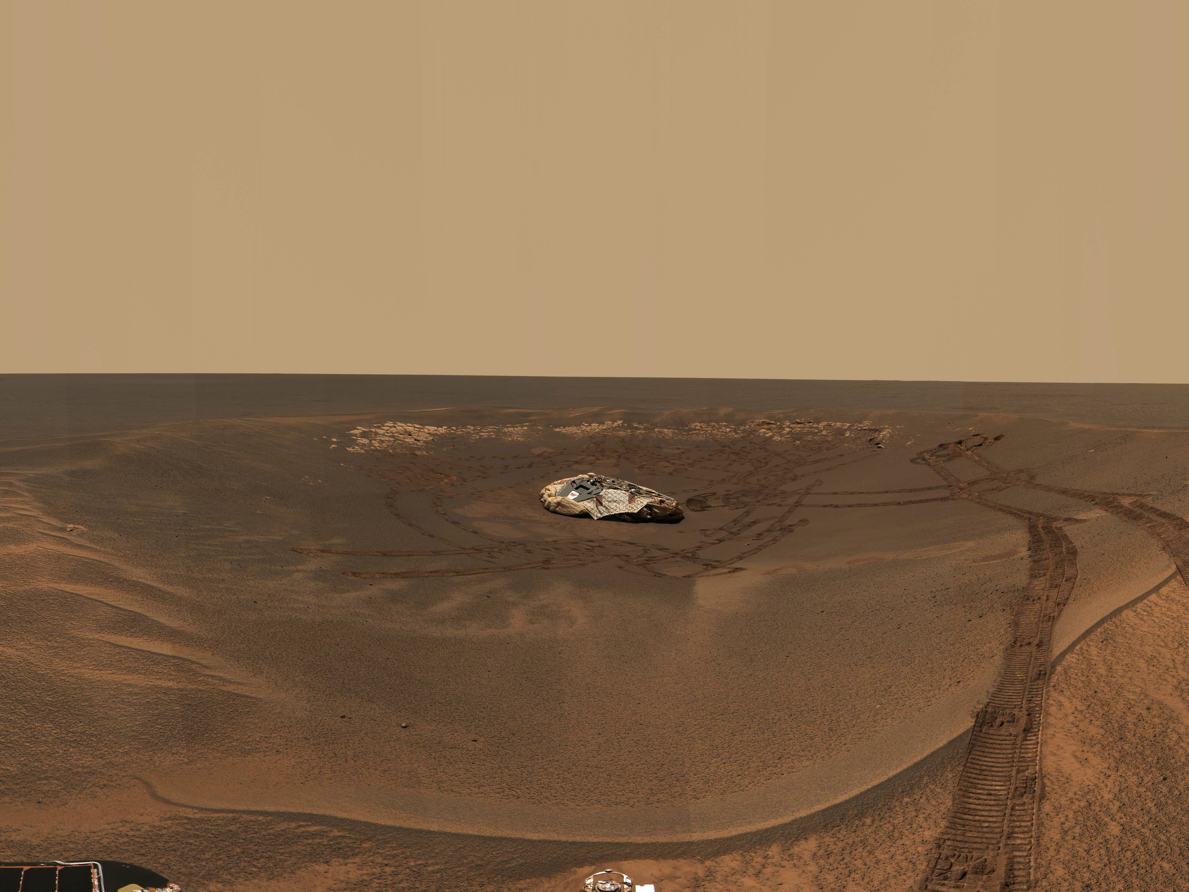
Opportunity Captures 'Lion King' Panorama
Opportunity Captures "Lion King" Panorama

This approximate true-color panorama, dubbed "Lion King," shows "Eagle Crater" and the surrounding plains of Meridiani Planum. It was obtained by the Mars Exploration Rover Opportunity's panoramic camera on sols 58 and 60 using infrared (750-nanometer), green (530-nanometer) and blue (430-nanometer) filters.

This is the largest panorama obtained yet by either rover. It was taken in eight segments using six filters per segment, for a total of 558 images and more than 75 megabytes of data. Additional lower elevation tiers were added to ensure that the entire crater was covered in the mosaic.

This panorama depicts a story of exploration including the rover's lander, a thorough examination of the outcrop, a study of the soils at the near-side of the lander, a successful exit from Eagle Crater and finally the rover's next desination, the large crater dubbed "Endurance."

Image credit: NASA/JPL/Cornell
Browse Image | Medium Image (383 kB) | Large (3.3 MB)
 
Large (203 kB)
Bringing Out the Color in 'Bounce'

This false-color composite of the rock dubbed "Bounce" shows the rock after the Mars Exploration Rover Opportunity drilled into it with its rock abrasion tool.

The drilling of the 7-millimeter-deep (0.3-inch) hole generated a bright powder. The color in this image has been enhanced to show that these tailings are relatively blue when compared with the unaltered rock (to the human eye, the tailings would appear red).

This image was assembled from the infrared (750-nanometer), green (530-nanometer) and violet (430-nanometer) filters of the rover's panoramic camera. It was taken on sol 68.

Image credit: NASA/JPL/Cornell
Browse Image (52 kB) | Large (1 MB)
The Many Sides of 'Bounce'

This graph shows light signatures, or spectra, taken from five different places on the rock dubbed "Bounce" at Meridiani Planum. The green and yellow spectra are from the bright rock powder and dark rock surface respectively. These spectra show a drop in reflectance near the one-micron wavelength mark, consistent with a less-oxidized, iron-bearing silicate such as olivine or pyroxene. These findings are not inconsistent with this rock being a basaltic rock. The relative brightness of the powder can be explained by particle sizes.

The red spectrum is from the bright dusty soil next to Bounce. The spectrum is dominated by the signature of oxidized "ferric" iron (Fe3+) like that seen in the classic martian dust. The teal spectrum is from the darker Meridiani soils. That spectrum is also dominated by ferric iron, though the reflectivity is lower probably because the grains are coarser in these soils compared to the dust.

The purple spectrum from the larger granules in the Meridiani soil show a fine-grained iron oxide (Fe3+) component. These data were acquired by the Mars Exploration Rover Opportunity's panoramic camera.

Image credit: NASA/JPL/Cornell
Browse Image (30 kB) | Large (283 kB)
'Bounce': Not Like the Others

This illustration shows that the rock dubbed "Bounce" near the Mars Exploration Rover Opportunity's landing region at Meridiani Planum is not made up of the same minerals as surrounding soil. Spectra from three soil samples taken outside of "Eagle Crater" are compared to that of Bounce (bottom). The dashed white line in the center of the spectra indicates where the "fingerprint" for triple-oxidized iron (Fe 3+) occurs. While the soil samples possess this feature, Bounce does not. The results suggest that Bounce did not originate in the plains of Meridiani Planum. These spectra were taken by the rover's Mössbauer spectrometer. Measurements of Bounce were made on sol 67.

Image credit: NASA/JPL/Cornell/University of Mainz
Browse Image (29 kB) | Large (103 kB)
'Bounce' and Shergotty Share Common Ground

This illustration compares the spectrum of "Bounce," a rock at Meridiani Planum, to that of a martian meteorite found on Earth called Shergotty. Bounce's spectrum, and thus mineral composition, is unique to the rocks studied so far at Merdiani Planum and Gusev Crater, the landings sites of the Mars Exploration Rovers Opportunity and Spirit. However, the results here indicate that Bounce is not a one-of-a-kind rock, but shares origins with Shergotty. Shergotty landed in India in 1865. Bounce's spectra were taken on sol 67 by Opportunity's Mössbauer spectrometer.

Image credit: NASA/JPL/Cornell/University of Mainz
Browse Image (28 kB) | Large (90 kB)
 
Browse Image (30 kB) | Large (66 kB)
Meteorite Linked to Rock at Meridiani

This meteorite, a basalt lava rock nearly indistinguishable from many Earth rocks, provided the first strong proof that meteorites could come from Mars. Originally weighing nearly 8 kilograms (17.6 pounds), it was collected in 1979 in the Elephant Moraine area of Antarctica. The side of the cube at the lower left in this image measures 1 centimeter (0.4 inches).

This picture shows a sawn face of this fine-grained gray rock. (The vertical stripes are saw marks.) The black patches in the rock are melted rock, or glass, formed when a large meteorite hit Mars near the rock. The meteorite impact probably threw this rock, dubbed "EETA79001," off Mars and toward Antarctica on Earth. The black glass contains traces of martian atmosphere gases.

The Mars Exploration Rover Opportunity has discovered that a rock dubbed "Bounce" at Meridiani Planum has a very similar mineral composition to this meteorite and likely shares common origins. Bounce itself is thought to have originated outside the area surrounding Opportunity's landing site; an impact or collision likely threw the rock away from its primary home.

Image credit: NASA/JSC/JPL/Lunar Planetary Institute
Browse Image | Medium Image (191 kB) | Large (2.2 kB)
'Bounce' and Martian Meteorite of the Same Mold

These two sets of bar graphs compare the elemental compositions of six martian rocks: "Bounce," located at Meridiani Planum; EETA79001-B, a martian meteorite found in Antarctica in 1979; a rock found at the Mars Pathfinder landing site; Shergotty, a martian meteorite that landed in India in 1865; "Adirondack," located at Gusev Crater; and "Humphrey," also located at Gusev Crater. The graph on the left compares magnesium/iron ratios in the rocks, and the graph on the right compares aluminum/calcium ratios. The results illustrate the diversity of rocks on Mars and indicate that Bounce probably shares origins with the martian meterorite EETA79001-B. The Bounce data was taken on sol 68 by the alpha particle X-ray spectrometer on Mars Exploration Rover Opportunity.

Image credit: NASA/JPL/Cornell/Max Planck Institute
Browse Image | Medium Image (52 kB) | Large (86 kB)
 
Browse Image (26 kB) | Large (74 kB)
'Bounce' Gets a Thorough Read

This image shows the rock dubbed "Bounce" near the Mars Exploration Rover Opportunity's landing site at Meridiani Planum, Mars. The two colored spots show where scientists took measurements of the rock with the rover's miniature thermal emission spectrometer. The area on the right is untouched rock and the area on the left is where the rover drilled a hole. This image was taken by the rover's panoramic camera.

Image credit: NASA/JPL/Cornell
Browse Image (35 kB) | Large (154 kB)
'RAT' Leaves a Fine Mess

This graph shows the light signatures, or spectra, of two sides of the rock dubbed "Bounce," located at Meridiani Planum, Mars. The spectra were taken by the miniature thermal emission spectrometer on the Mars Exploration Rover Opportunity. The left side of this rock is covered by fine dust created when the rover drilled into the rock with its rock abrasion tool. These "fines" produce a layer of pyroxene dust that can be detected here in the top spectrum. The right side of the rock has fewer fines and was used to investigate the composition of this basaltic rock.

Image credit: NASA/JPL/Cornell/ASU
Browse Image (28 kB) | Large (138 kB)
Best Fit for 'Bounce'

The mineralogy of "Bounce" rock was determined by fitting spectra from a library of laboratory minerals to the spectrum of Bounce taken by the Mars Exploration Rover Opportunity's miniature thermal emission spectrometer. The minerals that give the best fit include pyroxene, plagioclase and olivine -- minerals commonly found in basaltic volcanic rocks -- and typical martian dust produced by the rover's rock abrasion tool.

Image credit: NASA/JPL/Cornell/ASU
Browse Image (25 kB) | Large (118 kB)
Recipe for 'Bounce' Rock

The mineralogy of "Bounce" rock was determined by fitting spectra from a library of laboratory minerals to spectra of Bounce taken by the Mars Exploration Rover Opportunity's miniature thermal emission spectrometer. Bounce is made-up of 69 percent pyroxene, 20 percent plagioclase, and 11 percent olivine. The pyroxene minerals are primarily calcium-rich varieties, with smaller amounts of a class of minerals called orthopyroxenes. The composition of Bounce is significantly different from that of typical martian basalts seen over much of the surface from orbit by the Mars Global Surveyor thermal emission spectrometer. The rock's composition is, however, similar to that of meteorites thought to have come from Mars. No detectable hematite was found in Bounce.

Image credit: NASA/JPL/Cornell/ASU
Browse Image | Medium Image (82 kB) | Large (411 kB)
Flung Far from Home
Flung Far from Home

The rock dubbed "Bounce" at Meridiani Planum, Mars, may have been thrown onto the plains during an impact that formed a 25-kilometer-diameter (15.5-mile) crater (arrow) located 50 kilometers (31 miles) southeast of the Mars Exploration Rover Opportunity landing site (to the right of ellipse center). This infrared image, taken by the thermal emission imaging system on the Mars Odyssey orbiter, shows the pattern of ejecta, or material, thrown from the large crater. Rays of this rocky material can be seen radiating outward from the crater. The Opportunity landing site is close to one of these rays, as well as other rays of small impact craters seen in high-resolution Mars Odyssey camera images within 5 kilometers (3.1 miles) of the landing site. Bounce rock may be a smaller piece of material ejected onto the plains by this impact event.

Image credit: NASA/JPL/ASU
Browse Image | Medium Image (136 kB) | Large (11.7 MB)
Flung Far from Home-2

The rock dubbed "Bounce" at Meridiani Planum, Mars, may have been thrown onto the plains during an impact that formed a 25-kilometer-diameter (15.5-mile) crater (arrow) located 50 kilometers (31 miles) southeast of the mars Exploration Rover Opportunity landing site (to the right of ellipse center). This infrared image, taken by the thermal emission imaging system on the Mars Odyssey orbiter at night, shows the pattern of ejecta, or material, thrown from the large crater. Large rocks on the surface stay warm at night and produce a bright signature. Rays of this rocky material can be seen radiating outward from the crater. The Opportunity landing site is close to one of these warm rays, as well as other rays of small impact craters seen in high-resolution Mars Odyssey camera images within 5 kilometers (3.1 miles) of the landing site. Bounce rock may be a smaller piece of material ejected onto the plains by this impact event.

Image credit: NASA/JPL/ASU
Browse Image | Medium Image (207 kB) | Large (8.4 MB)
Flung Far from Home (zoom)

The rock dubbed "Bounce" at Meridiani Planum, Mars, may have been thrown onto the plains during an impact that formed a 25-kilometer-diameter (15.5-mile) crater (lower left) located 50 kilometers (31 miles) southeast of the Mars Exploration Rover Opportunity landing site (to the right of ellipse center). This infrared image, taken by the thermal emission imaging system on the Mars Odyssey orbiter at night, shows the pattern of ejecta, or material, thrown from the large crater. Large rocks on the surface stay warm at night and produce a bright signature. Rays of this rocky material can be seen radiating outward from the crater. The Opportunity landing site is close to one of these warm rays, as well as other rays of small impact craters seen in high-resolution Mars Odyssey camera images within 5 kilometers (3.1 miles) of the landing site. Bounce rock may be a smaller piece of material ejected onto the plains by this impact event.

Image credit: NASA/JPL/ASU
Browse Imag | Medium Image (198 kB) | Large (7 MB)
Flung Far from Home (zoom-2)

The rock dubbed "Bounce" at Meridiani Planum, Mars, may have been thrown onto the plains during an impact that formed a 25-kilometer-diameter (15.5-mile) crater (lower left) located 50 kilometers (31 miles) southeast of the Mars Exploration Rover Opportunity landing site (to the right of ellipse center). This infrared image, taken by the thermal emission imaging system on the Mars Odyssey orbiter, shows the pattern of ejecta, or material, thrown from the large crater. Rays of this rocky material can be seen radiating outward from the crater. The Opportunity landing site is close to one of these warm rays, as well as other rays of small impact craters seen in high-resolution Mars Odyssey camera images within 5 kilometers (3.1 miles) of the landing site. Bounce rock may be a smaller piece of material ejected onto the plains by this impact event.

Image credit: NASA/JPL/ASU
Browse Image | Medium Image (111 kB) | Large (938 kB)

JPL Image Use Policy

USA.gov
PRIVACY   I   IMAGE POLICY   I   FAQ   I   SITEMAP   I   CREDITS