08-Apr-2004
|
NASA Extends Mars Rovers' Mission
Full Press Release
|
 |
Spirit's Journey Continues
This map shows the path the Mars Exploration Rover Spirit has traveled since arriving on the red planet over 3 months ago. Spirit is still situated on the ejecta, or ejected material, of the 150-meter-wide (492-foot) crater dubbed "Bonneville." The ejecta appears white in this overhead image taken by the rover's descent image motion estimation system camera. The rover has stopped to investigate a rock called "Route 66," and will remain there, with its Moessbauer spectrometer pressed on the rock, through flight software updates scheduled to end on sol 98. During this time, the Moessbauer will take measurements of the rock. The alpha particle X-ray spectrometer , located on the opposite side of the rover's arm from the Moessbauer, will also be at work, acquiring data of the martian atmosphere for calibration purposes. Spirit is on its way to the eastern-lying "Columbia Hills."
Image credit: NASA/JPL
|
|
Browse Image (40 kB) |
Large (669 kB)
|
|
 |
Spirit's Prime-Mission Traverse
A traverse map for NASA's Mars Exploration Rover Spirit traces the path Spirit drove during its prime mission of 90 sols. The base image for this map was taken seconds before landing by Spirit's downward-looking descent image motion estimation system camera.
Image credit: NASA/JPL/New Mexico Museum of Natural History
|
|
Browse Image |
Medium Image (124 kB) |
Large (669 kB)
|
|
 |
Spirit's Extended-Mission Destination
The drive route planned for NASA's Mars Exploration Rover Spirit during its extended mission is represented by the green line in this traverse map. The gold line traces the path Spirit drove during its prime mission of 90 sols.
One objective for the rover's extended mission is to continue eastward to reach the high ground named "Columbia Hills," still about 2 kilometers (1.2 miles) away at the beginning of the extended mission.
The base image for this map was taken from orbit by NASA's Mars Global Surveyor. The entire area is within Gusev Crater.
Image credit: NASA/JPL/MSSS/New Mexico Museum of Natural History
|
|
Browse Image (36 kB) |
Large (120 kB)
|
|
 |
Looking Back, Spirit Sol 90
Following a long drive, NASA's Mars Exploration Rover Spirit took this backwards glance at its tracks across the landscape on sol 90 of its mission (April 4, 2004). The image is from Spirit's navigation camera.
Image credit: NASA/JPL
|
|
Browse Image (71 kB) |
Large (365 kB)
|
|
 |
90 Sols in 90 Seconds
In 90 martian days, NASA's Mars Exploration Rover Spirit has performed a remarkable series of drives, digs and scientific investigations at Gusev Crater, Mars. This video documents many of the rover's accomplishments by stringing together images taken throughout the mission by the rover's front hazard-avoidance camera and microscopic imager instrument.
Image credit: NASA/JPL/Cornell/USGS
|
|
Browse Image (39 kB) |
Large (187 kB) |
Video
|
|
|
|
 |
Heading for the Hills
This enhanced false-color mosaic image from the Mars Exploration Rover Spirit panoramic camera shows the view acquired after the rover drove approximately 50.2 meters (165 feet) on the martian afternoon of sol 89 (April 3, 2004). The view shows the direction of the rover's future drive destination. In the distance are the eastern-lying "Columbia Hills." This image was assembled from images in the panoramic camera's near-infrared (750 nanometer), green (530 nanometer), and violet (432 nanometer) filters. The colors have been exaggerated to enhance the differences between cleaner and dustier rocks, and lighter and darker soils.
Image credit: NASA/JPL/Cornell
|
|
Browse Image |
Medium Image (464 kB) |
Large (3.7 MB)
|
|
|
|
 |
Heading for the Hills
This mosaic image from the Mars Exploration Rover Spirit panoramic camera shows the view acquired after the rover drove 50.2 meters (165 feet) on the martian afternoon of sol 89 (April 3, 2004). The view shows the direction of the rover's future drive destination. In the distance are the eastern-lying "Columbia Hills." This image was assembled from images in the panoramic camera's green (530 nanometer) filter.
Image credit: NASA/JPL/Cornell
|
|
Browse Image |
Medium Image (306 kB) |
Large (1.8 MB)
|
|
 |
|
 |
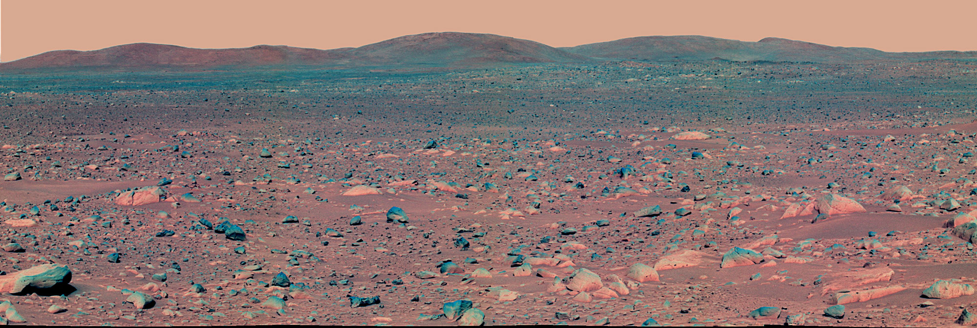
Light-toned Rocks First, 'Columbia Hills' Later
This image taken by the Mars Exploration Rover's panoramic camera on sol 91 (April 5, 2004) shows the rover's ultimate destination - the eastern-lying "Columbia Hills." The rover will head toward the hills in coming sols, while stopping to investigate rocks and soils along the way. Of particular interest is the light-toned coating seen here on the low-lying rocks. Scientists intend to find out if this coating is the same as that observed on the well-studied rock dubbed "Mazatzal." They believe Mazatzal's coating may have formed by cementation of airborne dust, perhaps in a slightly wetter, past environment. The scientists also plan to determine if the soil here is the same as the somewhat cohesive soil seen near the rover's lander. Like the coatings, this soil may have formed in past moist environments. This image was taken with the panoramic camera's infrared (750 nanometer) filter.
Image credit: NASA/JPL/Cornell
|
|
Browse Image (56 kB) |
Large (475 kB)
|
|


