September 30, 2003
Today, 30 September 2003, the Mars Global Surveyor (MGS) Mars Orbiter Camera (MOC) team is pleased to announce the release of 10,232 newly-validated, archived images acquired between August 2002 and February 2003. These MOC Extended Mission data were obtained during portions of the martian northern spring and summer seasons (autumn and winter in the southern hemisphere), and thus include many new views of north polar terrain, extremely clear-atmosphere views of Hellas Planitia, and a variety of martian landforms between the north pole and southern middle latitudes.
The new data can be viewed by visiting the Malin Space Science Systems
MOC Gallery.
The MOC Gallery now contains more than 134,000 images acquired by the
MGS camera since it began taking pictures in September 1997. The data
now span more than 2 full Mars years since the mapping phase of the
mission began in March 1999. Every six months, a new suite of MGS MOC
data are archived with the
NASA Planetary Data System (PDS).
Archiving occurs after a labor-intensive effort to validate the data acquired
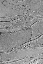
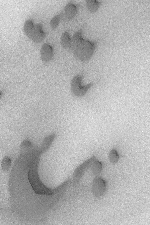
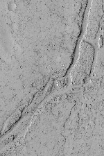
in the previous six-month period. The three pictures shown here are
examples of the high resolution data acquired during the August 2002
through February 2003 period.
Information about Mars Global Surveyor is available on the Internet at
http://marsprogram.jpl.nasa.gov/mgs.
JPL, a division of the California Institute of Technology, Pasadena,
manages Mars Global Surveyor for NASA's Office of Space Science in
Washington. JPL's industrial partner is Lockheed Martin Space Systems,
Denver, which developed and operates the spacecraft. Malin Space
Science Systems and the California Institute of Technology built the
Mars Orbiter Camera. Malin Space Science Systems operates the camera
from facilities in San Diego.
###
Ken Edgett (858) 552-2650 ext. 500
Malin Space Science Systems, San Diego, Calif.