NASA
NASA Science
Mars Exploration Program
Skip Navigation
menu
Images
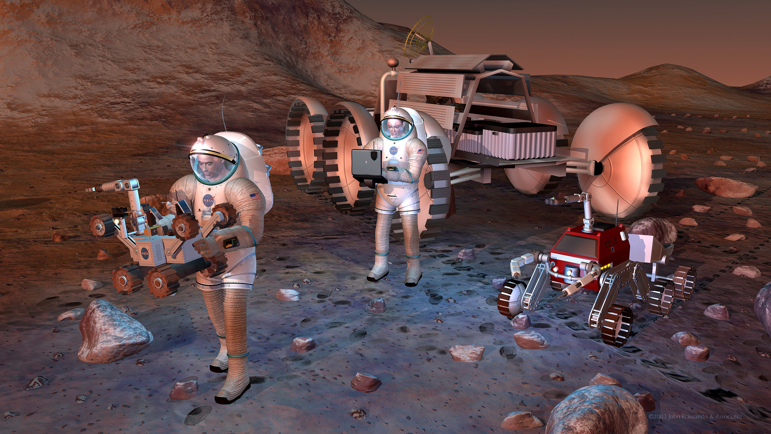
Artist's concept of future humans on Mars.
August 24, 2004
Credits
NASA/JPL-Caltech
ENLARGE
[51, 179]
Related
A "Grand Canyon of Mars" slices across the Red Planet near its equator.
Mars Canyon with Los Angeles for Scale
This series of images was taken in visible-wavelength light as the THEMIS camera on NASA's Mars Odyssey scanned across the Martian moon Phobos on Sept. 29, 2017. The apparent motion is due to progr...
Series of Images from THEMIS Scanning Phobos
This color-coded map indicates the depth to icy layers at a site in southern Mars. The dense, icy layer retains heat better than the looser soil above it, so where the icy layer is closer to the su...
Depth-to-Ice Map of a Southern Mars Site Near Melea Planum
This image from NASA's 2001 Mars Odyssey spacecraft shows part of the margin of the north polar cap and the surrounding plains. The layering of the ice is easily visible due to the dust that is dep...
Polar Layers
A vast dune field lies near the northern polar cap of Mars. Seen here in summer, the dunes have partially buried an impact crater about 1,000 meters (3,300 feet) wide.
Mars Odyssey All Stars: Dunes Engulf Crater
A small section of Dao Vallis in shown in this VIS image. Dao Vallis is a major channel that drains into Hellas Planitia
Dao Valles
This image from NASA's Mars Odyssey shows a crater from a double impact - two meteors hitting simultaneously. The two meteors would have started as a single object and, at some point prior to impac...
Doublet Crater
This pair of maps indicates locations of confirmed sites of recurrent slope linea on Mars, with respect to elevation (upper map) and surface brightness, or albedo (lower map).
Maps of Recurrent Slope Linea Markings on Mars
A false-color mosaic focuses on one junction in Noctis Labyrinthus where canyons meet to form a depression 4,000 meters (13,000 feet) deep.
Mars Odyssey All Stars: Noctis Canyon
Phobos and Deimos, the moons of Mars, are seen in this image from NASA's 2001 Mars Odyssey orbiter. The distance to Deimos from Odyssey during the observation was about 12,222 miles (19,670 kilomet...
Mars Odyssey Observes Martian Moons
A lunar eclipse, a solar eclipse and Mars has a close encounter with a comet.
What's Up for October?
Olympica Fossae is a complex channel located on the volcanic plains between Alba Mons and Olympus Mons. The sinuosity of the large channel in the middle of this image from NASA's 2001 Mars Odyssey ...
Olympica Fossae
This map shows unprecedented detail of local variations in Mars' gravitational pull on orbiters. The gravitational mapping has been applied to map variations in the thickness of the planet's crust ...
Local Variations in the Gravitational Pull of Mars
Although this may look like a hostile alien life form, it's actually a complex line of sand dunes near the northern ice cap of Mars.
Mars Odyssey All Stars: Reptilian Dunes
This image from NASA's 2001 Mars Odyssey spacecraft shows part of the caldera floor of Arsia Mons. Arsia Mons is the southernmost of the Tharsis volcanoes. It is 270 miles in diameter, almost 12 mi...
Investigating Mars: Arsia Mons
Download a PDF of the Mars Odyssey Fact Sheet.
Odyssey Fact Sheet
This animation shows how NASA's Curiosity rover communicates with Earth via two of NASA's Mars orbiters, Mars Reconnaissance Orbiter (MRO) and Odyssey, and the European Space Agency's Mars Express....
Curiosity Communicates with Help From Its 'Friends'
Martian surface frost, made up largely of carbon dioxide, appears blueish-white in these images from the Thermal Emission Imaging System (THEMIS) camera aboard NASA’s 2001 Odyssey orbiter. THEMIS t...
Four Images of Morning Frost on Mars
Ninth-grade, high-school students from Peoria, AZ analyze images of Mars.
Student Teams Work As Real Scientists
2021_WindingTributary.jpg
Winding Side Canyon (Louros Valles)
Sixteen seventh-graders at Evergreen Middle School in Cottonwood, Calif., found the Martian pit feature at the center of the superimposed red square in this image while participating in a program t...
Martian Pit Feature Found by Seventh Graders
This image shows the context for orbital observations of exposed rocks that had been buried an estimated 5 kilometers (3 miles) deep on Mars.
Nature's Drilling Exposes Deeply Buried Minerals
This lava channel is part of the Elysium Mons flows.
Lava Channel
This computer-generated view based on multiple orbital observations shows Mars' Gale crater as if seen from an aircraft north of the crater.
Oblique view of Gale Crater from the North (Unannotated)
Seasons change even on Mars and NASA's fleet of explorers are helping scientists learn more about the effects on the Red Planet.
Mars Report: How's the Weather on Mars?
You Might Also Like
The agency is asking the NASA community to work together to develop a revised plan that leverages innovation and proven technology.
NASA Sets Path to Return Mars Samples, Seeks Innovative Designs
NASA has proven powered, controlled flight is possible on other worlds, just as the Wright brothers proved it was possible on Earth.
After Three Years on Mars, NASA's Ingenuity Helicopter Mission Ends
The agency established the board in May 2023 to evaluate the technical, cost, and schedule plans prior to confirmation of the mission’s design.
NASA Releases Independent Review's Mars Sample Return Report
A pair of quakes in 2021 sent seismic waves deep into the Red Planet’s core, giving scientists the best data yet on its size and composition.
NASA InSight Study Provides Clearest Look Ever at Martian Core
Ten sample tubes, capturing an amazing variety of Martian geology, have been deposited on Mars’ surface so they could be studied on Earth in the future.
NASA's Perseverance Rover Completes Mars Sample Depot
Filled with rock, the sample tube will be one of 10 forming a depot of tubes that could be considered for a journey to Earth by the Mars Sample Return campaign.
NASA's Perseverance Rover Deposits First Sample on Mars Surface