Images
Cerberus Fossae - Athabasca Valles

November 18, 2021
Context image
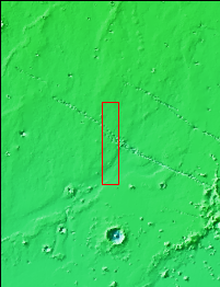
Today's VIS image shows a section of Cerberus Fossae. Located southeast of the Elysium Planitia volcanic complex, the linear graben in the image were created by tectonic forces related to the volcanic activity. The graben are sources of both channels and significant volcanic flows. The Cerberus Fossae graben cut across features such as hills, indicating the relative youth of the tectonic activity. Graben form where extensional tectonic forces allows blocks of material to subside between paired faults. Cerberus Fossae are 270km (168 miles) long.
Just off the image to the right is the start of Athabasca Valles, which is seen flowing below the graben to the bottom left of the image. Arising from Cerberus Fossae, the formation mode of this channel is still being debated. While the channel features are similar to water flow, other features are similar to lava flows, and yet other features have an appearance of slabs of material that floated on an underlying fluid. It is thought that Athabasca Valles is the youngest outflow channel system on Mars. Athabasca Valles is just one of the complex channel formations in the Elysium Planitia region.
The THEMIS VIS camera is capable of capturing color images of the Martian surface using five different color filters. In this mode of operation, the spatial resolution and coverage of the image must be reduced to accommodate the additional data volume produced from using multiple filters. To make a color image, three of the five filter images (each in grayscale) are selected. Each is contrast enhanced and then converted to a red, green, or blue intensity image. These three images are then combined to produce a full color, single image. Because the THEMIS color filters don't span the full range of colors seen by the human eye, a color THEMIS image does not represent true color. Also, because each single-filter image is contrast enhanced before inclusion in the three-color image, the apparent color variation of the scene is exaggerated. Nevertheless, the color variation that does appear is representative of some change in color, however subtle, in the actual scene. Note that the long edges of THEMIS color images typically contain color artifacts that do not represent surface variation.
Orbit Number: 86770 Latitude: 10.3516 Longitude: 156.539 Instrument: VIS Captured: 2021-07-06 22:48
Please see the THEMIS Data Citation Note for details on crediting THEMIS images.
NASA's Jet Propulsion Laboratory manages the 2001 Mars Odyssey mission for NASA's Science Mission Directorate, Washington, D.C. The Thermal Emission Imaging System (THEMIS) was developed by Arizona State University, Tempe, in collaboration with Raytheon Santa Barbara Remote Sensing. The THEMIS investigation is led by Dr. Philip Christensen at Arizona State University. Lockheed Martin Astronautics, Denver, is the prime contractor for the Odyssey project, and developed and built the orbiter. Mission operations are conducted jointly from Lockheed Martin and from JPL, a division of the California Institute of Technology in Pasadena.