Illustrating MastCam Capabilities with a Terrestrial Scene

| Credit | NASA/JPL-Caltech/MSSS |
|---|---|
| Language |
|
This set of views illustrates capabilities of the Mast Camera (MastCam) instrument on the Mars Science Laboratory's Curiosity rover, using a scene on Earth as an example of what MastCam's two cameras can see from different distances.
The images show a rock outcrop just south of Green River, Utah, of ancient (Jurassic Period, around 150 Million years old) rocks exposed by erosion of a large amount of sedimentary rock in the area. These images were taken with a consumer camera with a Bayer Filter Array and a pixel size very similar to that of the MastCam, through lenses with the same focal lengths as the MastCams. In all these examples, the term "resolution" is defined as three times the per-pixel scale; that is, it takes three pixels as a minumum to "resolve" a feature.
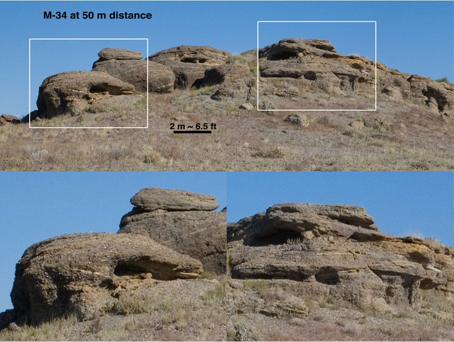
The initial view simulates what the 34-millimeter-focal-length MastCam (M-34) resolves in a rock outcrop from a distance of 120 yards (100 meters). That is the distance between goal posts on a standard America football field. The white boxes in the upper view show the outlines of the two lower, enlarged views, and are about 10 yards (9 meters) across. Features about 3 inches (8 centimeters) across are resolvable in this view.

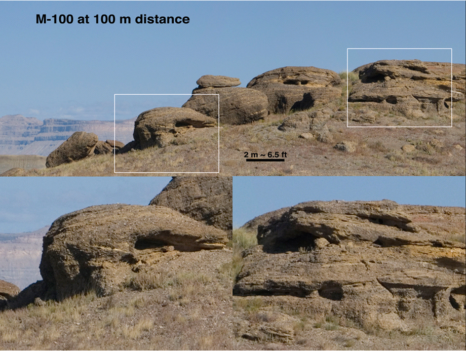
Figure 1 simulates imaging with the 100-millimeter-focal-length MastCam (M-100) from the same distance. The M-100 resolution at 120 yards (100 meters) distance is about 0.9 inch (2.25 centimeters). The white boxes in this example are about as wide as the separation of the vertical uprights of a goal post (18.67 feet, ot 17.1 meters). One can see in the lower left image many rounded dots in the rock; these are pebbles and cobbles that were transported into the area, and they are seen and interpreted in later figures of this series.
Browse Image | Medium Image | Full Res Image

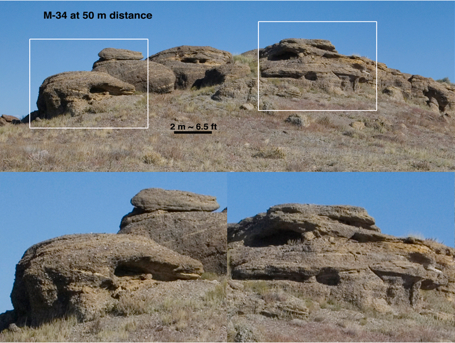
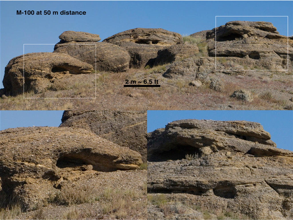
Figure 2 simulates imaging of the same outcrop with M-34 from a distance of 55 yards (50 meters). The white boxes are as wide as the separation between uprights on a goal post. The resolution is about 1.5 inches (4 centimeters). Although twice as close, this image is not quite at the same resolution as the M-100 image taken from 100 meters distance (Fig. 1).
Browse Image | Medium Image | Full Res Image

Figure 3 simulates imaging with M-100 from 55 yards (50 meters). From this distance, M-100 can resolve objects 0.45 inch (1.1 centimeter) across. In this view one can clearly see the pebbles and cobbles in the image in the lower left, and layers of both resolved stones and layers without such large features in the image on the right.
Browse Image | Medium Image | Full Res Image
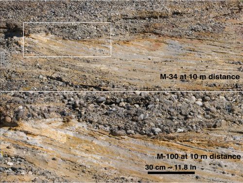
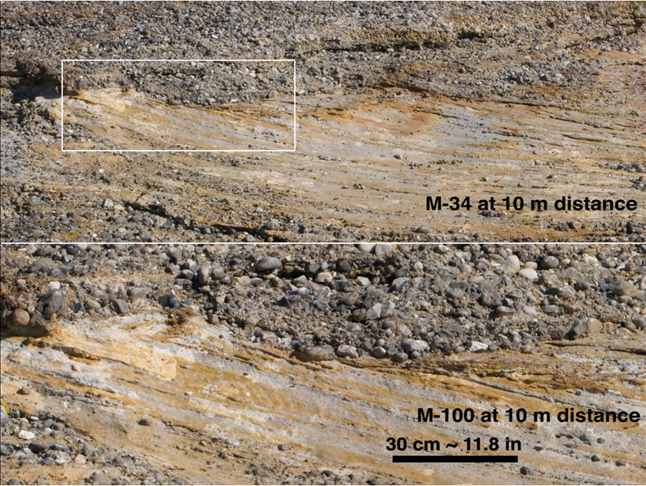
Figure 4 simulates both MastCams from roughly 11 yards (10 meters), the distance from the 1 yard line to the goal post. The top image (M-34 equivalent) covers an area about 14 feet (4.3 meters) across and has a resolution of one-third of an inch (0.84 centimeter). The bottom image (M-100 equivalent) covers an area 61 inches (1.55 meters) across and has a resolution of one-eleventh of an inch (less than a quarter of a centimeter). This image shows a dark-toned, water-lain, pebble conglomerate with well worn (rounded) stones overlying a lighter-toned, river-formed sandstone. The pebbles are about 1 to 2 inches (2.5 to 5 centimeters) in diameter, which requires the water that transported them to be flowing briskly. The grey and tan layers in the sandstone are also about 1 to 2 inches (2.5 to 5 centimeters) thick.
Browse Image | Medium Image | Full Res Image
The sandstone and conglomerate interpretations were possible at a distance of between 50 and 100 meters, and the details of the interpretation of the flow regime were possible at distances of less than 20 meters.
Malin Space Science Systems, San Diego, built MastCam and two other cameras on Curiosity. NASA's Jet Propulsion Laboratory, a division of the California Institute of Technology in Pasadena, manages the Mars Science Laboratory Project for the NASA Science Mission Directorate, Washington.
